IMAGES TAKEN NEAR TO
Tattingstone, IPSWICH, IP9 2NS
Introduction
This page details the photographs taken nearby to IP9 2NS by members of the Geograph project.
The Geograph project started in 2005 with the aim of publishing, organising and preserving representative images for every square kilometre of Great Britain, Ireland and the Isle of Man.

There are currently over 7.5m images from over14,400 individuals and you can help contribute to the project by visiting https://www.geograph.org.uk
Image Map
Images are licensed for reuse under creativecommons.org/licenses/by-sa/2.0
Notes
- Clicking on the map will re-center to the selected point.
- The higher the marker number, the further away the image location is from the centre of the postcode.
Image Listing (16 Images Found)
Images are licensed for reuse under creativecommons.org/licenses/by-sa/2.0
Image
Details
Distance
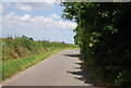
1
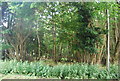
Path near Alton Water
Close to the car park near Birchwood House
Image: © Roger Jones
Taken: 17 Jul 2011
0.13 miles
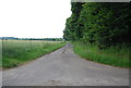
5
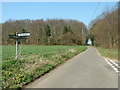
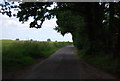
Road Junction
Road junction near to Holbrook Suffolk. The wood to the right of the road is marked on the 1:25:000 O.S. is known as Woodley wood and to the left of the road as Little Birch Wood.
Image: © Keith Evans
Taken: 1 Apr 2007
0.18 miles

9
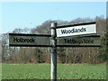
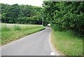
Road Junction Sign
Road junction sign near to Holbrook Suffolk.
Image: © Keith Evans
Taken: 1 Apr 2007
0.19 miles