IMAGES TAKEN NEAR TO
Bentley, IPSWICH, IP9 2LS
Introduction
This page details the photographs taken nearby to IP9 2LS by members of the Geograph project.
The Geograph project started in 2005 with the aim of publishing, organising and preserving representative images for every square kilometre of Great Britain, Ireland and the Isle of Man.

There are currently over 7.5m images from over14,400 individuals and you can help contribute to the project by visiting https://www.geograph.org.uk
Image Map
Images are licensed for reuse under creativecommons.org/licenses/by-sa/2.0
Notes
- Clicking on the map will re-center to the selected point.
- The higher the marker number, the further away the image location is from the centre of the postcode.
Image Listing (5 Images Found)
Images are licensed for reuse under creativecommons.org/licenses/by-sa/2.0
Image
Details
Distance
1
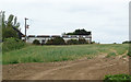
Footpath and farm buildings, Hubbard's Hall Farm
This public footpath leads past some farm buildings at Hubbard's Hall Farm, Bentley.
Image: © Roger Jones
Taken: 12 Jun 2011
0.02 miles
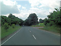
2
Bridlepath towards Bentley Manor
Looking west from the junction in the paths near Hubbard's Hall Farm.
Image: © Simon Mortimer
Taken: 23 Dec 2016
0.18 miles
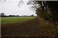
5
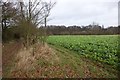
Farmland near Hubbard's Hall Farm
Looking north along the bridlepath, with Wherstead Wood on the horizon.
Image: © Simon Mortimer
Taken: 23 Dec 2016
0.22 miles