IMAGES TAKEN NEAR TO
Hare Fields, IPSWICH, IP9 2FR
Introduction
This page details the photographs taken nearby to Hare Fields, IP9 2FR by members of the Geograph project.
The Geograph project started in 2005 with the aim of publishing, organising and preserving representative images for every square kilometre of Great Britain, Ireland and the Isle of Man.

There are currently over 7.5m images from over14,400 individuals and you can help contribute to the project by visiting https://www.geograph.org.uk
Image Map
Images are licensed for reuse under creativecommons.org/licenses/by-sa/2.0
Notes
- Clicking on the map will re-center to the selected point.
- The higher the marker number, the further away the image location is from the centre of the postcode.
Image Listing (38 Images Found)
Images are licensed for reuse under creativecommons.org/licenses/by-sa/2.0
Image
Details
Distance
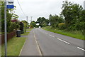
4
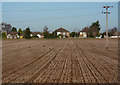
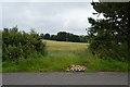
Field and houses on Holbrook Road
There were lots of crows in the field, finding food amongst the stubble.
Image: © Andrew Hill
Taken: 1 Dec 2009
0.07 miles
5
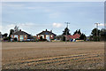
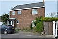
Houses on Holbrook Road, Stutton
Looking across from Church Field Road.
Image: © Robin Webster
Taken: 26 Nov 2017
0.08 miles
7
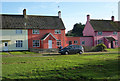
Houses on Stutton Close
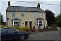
Brightly coloured houses on this residential village street.
Image: © Andrew Hill
Taken: 1 Dec 2009
0.10 miles