IMAGES TAKEN NEAR TO
Vicarage Lane, IPSWICH, IP9 2AE
Introduction
This page details the photographs taken nearby to Vicarage Lane, IP9 2AE by members of the Geograph project.
The Geograph project started in 2005 with the aim of publishing, organising and preserving representative images for every square kilometre of Great Britain, Ireland and the Isle of Man.

There are currently over 7.5m images from over14,400 individuals and you can help contribute to the project by visiting https://www.geograph.org.uk
Image Map
Images are licensed for reuse under creativecommons.org/licenses/by-sa/2.0
Notes
- Clicking on the map will re-center to the selected point.
- The higher the marker number, the further away the image location is from the centre of the postcode.
Image Listing (9 Images Found)
Images are licensed for reuse under creativecommons.org/licenses/by-sa/2.0
Image
Details
Distance
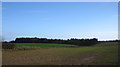
1
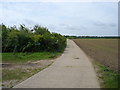
Cultivated field south of Park Farm, Wherstead
Looking east from Vicarage Lane.
Image: © Simon Mortimer
Taken: 30 Mar 2019
0.12 miles
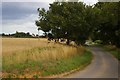
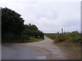
2
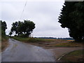
Vicarage Lane & footpath to Freston Street
Near Orwell Nursing Home
Image: © Geographer
Taken: 22 Aug 2013
0.15 miles
3
Footpath to Freston Street
Off Vicarage Lane near Orwell Nursing Home
Image: © Geographer
Taken: 22 Aug 2013
0.15 miles
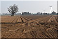
5
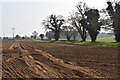
Ploughed field and trees lining Vicarage Lane, Wherstead
Looking south-east from the lane just south of Park Farm.
Image: © Simon Mortimer
Taken: 30 Mar 2019
0.19 miles
7
Bridleway to Valley Farm & Valley Lane
Off Vicarage Lane
Image: © Geographer
Taken: 22 Aug 2013
0.23 miles
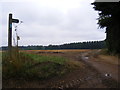
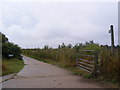
8
Vicarage Lane & bridleway to Valley Farm & Lane
Image: © Geographer
Taken: 22 Aug 2013
0.23 miles