IMAGES TAKEN NEAR TO
Lower Harlings, IPSWICH, IP9 1RP
Introduction
This page details the photographs taken nearby to Lower Harlings, IP9 1RP by members of the Geograph project.
The Geograph project started in 2005 with the aim of publishing, organising and preserving representative images for every square kilometre of Great Britain, Ireland and the Isle of Man.

There are currently over 7.5m images from over14,400 individuals and you can help contribute to the project by visiting https://www.geograph.org.uk
Image Map
Images are licensed for reuse under creativecommons.org/licenses/by-sa/2.0
Notes
- Clicking on the map will re-center to the selected point.
- The higher the marker number, the further away the image location is from the centre of the postcode.
Image Listing (43 Images Found)
Images are licensed for reuse under creativecommons.org/licenses/by-sa/2.0
Image
Details
Distance
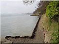

3
Stour and Orwell Walk at Shotley Cliff
Looking east towards Shotley Pier.
Image: © Simon Mortimer
Taken: 30 Mar 2021
0.15 miles
5
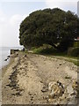
The road reaches the shore at Shotley Gate
Looking to a house and rather fine tree. The coast path passes under the tree.
Image: © Andrew Hill
Taken: 29 Aug 2008
0.16 miles
7

Stour Estuary
The vessel in the distance is loaded with wind turbine masts.
Image: © Tim Marchant
Taken: 27 Oct 2010
0.17 miles
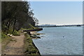
9
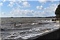
High tide in the Stour estuary
Looking west from the promenade at the foot of Bristol Hill in Shotley Gate.
Image: © Simon Mortimer
Taken: 10 Mar 2019
0.18 miles
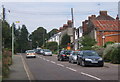
10
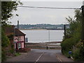
Shotley Gate IP9, Suffolk
The foot of Bristol Hill (i.e. the end of the B1456) is the terminus for the No.202 bus service that links this peninsula with Ipswich. A less frequent bus service, the No.98, crosses in front of The Bristol Arms - to the left - and makes its first/last stop inside Shotley Marina. This pub closed its doors to customers in mid-June 2012, only to re-open them in September 2012 under new management. The Stour estuary and the Parkeston Quay area provides the backdrop.
Image: © David Hallam-Jones
Taken: 28 May 2013
0.18 miles