IMAGES TAKEN NEAR TO
Shotley, IPSWICH, IP9 1PG
Introduction
This page details the photographs taken nearby to IP9 1PG by members of the Geograph project.
The Geograph project started in 2005 with the aim of publishing, organising and preserving representative images for every square kilometre of Great Britain, Ireland and the Isle of Man.

There are currently over 7.5m images from over14,400 individuals and you can help contribute to the project by visiting https://www.geograph.org.uk
Image Map
Images are licensed for reuse under creativecommons.org/licenses/by-sa/2.0
Notes
- Clicking on the map will re-center to the selected point.
- The higher the marker number, the further away the image location is from the centre of the postcode.
Image Listing (5 Images Found)
Images are licensed for reuse under creativecommons.org/licenses/by-sa/2.0
Image
Details
Distance
1
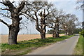
Veteran trees on Erwarton Walk
The trees are all that remains of an avenue that linked Erwarton Hall with the main road between Ipswich and Shotley. The second row of trees were in what is now an arable field and were lost in the middle of the 20th Century.
Image: © Simon Mortimer
Taken: 30 Mar 2019
0.10 miles
2
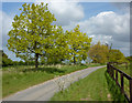
Lane and trees north of Erwarton Hall
A little cut through to the B1456.
Image: © Andrew Hill
Taken: 2 May 2009
0.20 miles
3
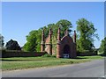
The Jacobean Gateway to Erwarton Hall
Built as a gatehouse to Erwarton hall in 1575.
Image: © Adrian S Pye
Taken: 20 Aug 2008
0.23 miles
4

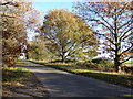
Shotley Walk
The lane leading to Shotley Hall and Church.
Image: © Tim Marchant
Taken: 27 Oct 2010
0.25 miles
5
Church Walk
The way to Church End, Shotley.
Image: © Robin Webster
Taken: 26 Nov 2017
0.25 miles