IMAGES TAKEN NEAR TO
Tudor Close, IPSWICH, IP9 1PA
Introduction
This page details the photographs taken nearby to Tudor Close, IP9 1PA by members of the Geograph project.
The Geograph project started in 2005 with the aim of publishing, organising and preserving representative images for every square kilometre of Great Britain, Ireland and the Isle of Man.

There are currently over 7.5m images from over14,400 individuals and you can help contribute to the project by visiting https://www.geograph.org.uk
Image Map
Images are licensed for reuse under creativecommons.org/licenses/by-sa/2.0
Notes
- Clicking on the map will re-center to the selected point.
- The higher the marker number, the further away the image location is from the centre of the postcode.
Image Listing (3 Images Found)
Images are licensed for reuse under creativecommons.org/licenses/by-sa/2.0
Image
Details
Distance
1
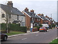
Last row of houses leaving Shotley Gate on the B1456
Image: © Andrew Hill
Taken: 29 Aug 2008
0.16 miles
2
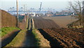
Shotley - rolling fields
Footpath to Shotley Gate. The telephoto lens foreshortens the view of the cranes at Felixstowe on the other side of the river Orwell.
Image: © Colin Denny
Taken: 14 Jan 2009
0.20 miles
3
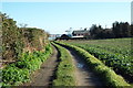
Stour and Orwell walk
The path as it approaches Shotley Gate, with the port of Felixstowe in the background.
Image: © Robin Lucas
Taken: 19 Feb 2016
0.20 miles