IMAGES TAKEN NEAR TO
Shotley, IPSWICH, IP9 1LG
Introduction
This page details the photographs taken nearby to IP9 1LG by members of the Geograph project.
The Geograph project started in 2005 with the aim of publishing, organising and preserving representative images for every square kilometre of Great Britain, Ireland and the Isle of Man.

There are currently over 7.5m images from over14,400 individuals and you can help contribute to the project by visiting https://www.geograph.org.uk
Image Map
Images are licensed for reuse under creativecommons.org/licenses/by-sa/2.0
Notes
- Clicking on the map will re-center to the selected point.
- The higher the marker number, the further away the image location is from the centre of the postcode.
Image Listing (12 Images Found)
Images are licensed for reuse under creativecommons.org/licenses/by-sa/2.0
Image
Details
Distance
1
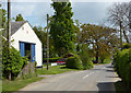
The end of the lane from Erwarton
Approaching the B1456 and the village of Shotley.
Image: © Andrew Hill
Taken: 2 May 2009
0.03 miles
2
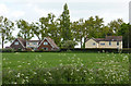
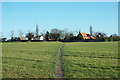
Field and the first houses in Shotley
From the lane to Erwarton.
Image: © Andrew Hill
Taken: 2 May 2009
0.03 miles
3
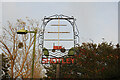
Shotley village sign
Shotley village sign, not unexpectedly, features the mast at Shotley’s HMS Ganges as its main component. A red tractor and leaves of the elm trees which were more abundant than they are now.
Image: © Adrian S Pye
Taken: 24 Oct 2020
0.06 miles
4
Shotley village sign
Shotley village sign, not unexpectedly, features the mast at Shotley’s HMS Ganges as its main component. A red tractor and leaves of the elm trees which were more abundant than they are now. https://www.geograph.org.uk/photo/6650996
Image: © Adrian S Pye
Taken: 24 Oct 2020
0.07 miles
5
Footpath near Shotley
From the Stour and Orwell walk, a footpath branches off to Shotley village.
Image: © Robin Lucas
Taken: 19 Feb 2016
0.08 miles
6
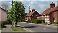
Village houses, The Street, Shotley
Looking west along the B1456.
Image: © Andrew Hill
Taken: 2 May 2009
0.15 miles
7
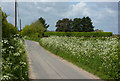
Lane between Shotley and Erwarton
Hedges and verges in their May display of cow or hedge parsley.
Image: © Andrew Hill
Taken: 2 May 2009
0.20 miles
8
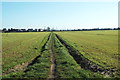
Stour and Orwell walk
The path crosses farmland as it approaches Shotley village.
Image: © Robin Lucas
Taken: 19 Feb 2016
0.20 miles
9
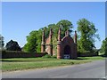
The Jacobean Gateway to Erwarton Hall
Built as a gatehouse to Erwarton hall in 1575.
Image: © Adrian S Pye
Taken: 20 Aug 2008
0.21 miles
10
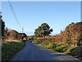
Lane towards Erwarton
Erwarton Hall Farm is ahead.
Image: © Robin Webster
Taken: 26 Nov 2017
0.23 miles