IMAGES TAKEN NEAR TO
Main Road, IPSWICH, IP9 1HL
Introduction
This page details the photographs taken nearby to Main Road, IP9 1HL by members of the Geograph project.
The Geograph project started in 2005 with the aim of publishing, organising and preserving representative images for every square kilometre of Great Britain, Ireland and the Isle of Man.

There are currently over 7.5m images from over14,400 individuals and you can help contribute to the project by visiting https://www.geograph.org.uk
Image Map
Images are licensed for reuse under creativecommons.org/licenses/by-sa/2.0
Notes
- Clicking on the map will re-center to the selected point.
- The higher the marker number, the further away the image location is from the centre of the postcode.
Image Listing (9 Images Found)
Images are licensed for reuse under creativecommons.org/licenses/by-sa/2.0
Image
Details
Distance
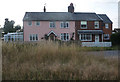
1
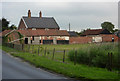
Walnut Tree Farm
By the B1456 west of Chelmondiston.
Image: © Andrew Hill
Taken: 7 Aug 2009
0.00 miles
4
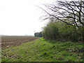
Footpath along the headland at Walnut Tree Farm
Image: © Adrian S Pye
Taken: 10 Apr 2015
0.05 miles
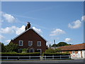
5
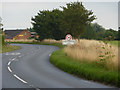
B1256 entering Chelmondiston
Looking from the northeast towards the edge of the village.
Image: © Andrew Hill
Taken: 7 Aug 2009
0.10 miles
6
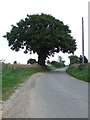
Bylam Lane
Bylam Lane near to Chelmondiston, Suffolk.
Image: © Keith Evans
Taken: 9 Oct 2013
0.16 miles
7
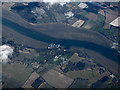
Woolverstone Park and the River Orwell from the air
Wolverstone Marina can be seen on the south bank of the River Orwell. Viewed from a Stansted bound flight from Prague.
Image: © Thomas Nugent
Taken: 16 Mar 2016
0.20 miles
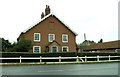
9
Bylam Cottage
Located by a sharp corner on Bylam Lane.
Image: © Andrew Hill
Taken: 7 Aug 2009
0.23 miles