IMAGES TAKEN NEAR TO
Shotley, IPSWICH, IP9 1EY
Introduction
This page details the photographs taken nearby to IP9 1EY by members of the Geograph project.
The Geograph project started in 2005 with the aim of publishing, organising and preserving representative images for every square kilometre of Great Britain, Ireland and the Isle of Man.

There are currently over 7.5m images from over14,400 individuals and you can help contribute to the project by visiting https://www.geograph.org.uk
Image Map
Images are licensed for reuse under creativecommons.org/licenses/by-sa/2.0
Notes
- Clicking on the map will re-center to the selected point.
- The higher the marker number, the further away the image location is from the centre of the postcode.
Image Listing (5 Images Found)
Images are licensed for reuse under creativecommons.org/licenses/by-sa/2.0
Image
Details
Distance
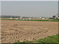
3
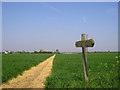
Shotley, Boot Drift, towards the Orwell.
This is the footpath between Shotley (Boot Drift) and Ewarton. Looking towards the Orwell (North) the masts in the distance are Levington Marina on the north bank of the River Orwell.
Image: © Ian McLean
Taken: 17 Jun 2005
0.08 miles
4
Porkers!
A bit near the houses on a hot day, especially after a drop of rain.
Image: © Adrian S Pye
Taken: 10 Apr 2015
0.10 miles