IMAGES TAKEN NEAR TO
Ayers Creek, IPSWICH, IP9 1EJ
Introduction
This page details the photographs taken nearby to Ayers Creek, IP9 1EJ by members of the Geograph project.
The Geograph project started in 2005 with the aim of publishing, organising and preserving representative images for every square kilometre of Great Britain, Ireland and the Isle of Man.

There are currently over 7.5m images from over14,400 individuals and you can help contribute to the project by visiting https://www.geograph.org.uk
Image Map
Images are licensed for reuse under creativecommons.org/licenses/by-sa/2.0
Notes
- Clicking on the map will re-center to the selected point.
- The higher the marker number, the further away the image location is from the centre of the postcode.
Image Listing (12 Images Found)
Images are licensed for reuse under creativecommons.org/licenses/by-sa/2.0
Image
Details
Distance
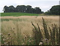
1
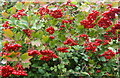
Guelder Rose berries, Vibernum opulus
Vivid red berries creating a lovely display.
Image: © Andrew Hill
Taken: 29 Aug 2008
0.06 miles
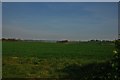
2
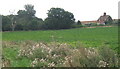
Field and Orwell Cottages in the distance
Image: © Andrew Hill
Taken: 29 Aug 2008
0.08 miles
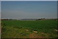
3
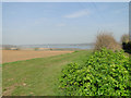
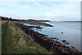
The land drops down the valley to the River Orwell
Image: © Adrian S Pye
Taken: 10 Apr 2015
0.09 miles
7
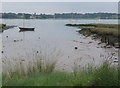
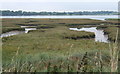
By the Orwell
Taken not long after the turn of high tide.
Image: © Andrew Hill
Taken: 29 Aug 2008
0.17 miles
10
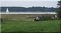
Field with two horses, overlooking the Orwell
Image: © Andrew Hill
Taken: 29 Aug 2008
0.23 miles