IMAGES TAKEN NEAR TO
Harkstead, IPSWICH, IP9 1DE
Introduction
This page details the photographs taken nearby to IP9 1DE by members of the Geograph project.
The Geograph project started in 2005 with the aim of publishing, organising and preserving representative images for every square kilometre of Great Britain, Ireland and the Isle of Man.

There are currently over 7.5m images from over14,400 individuals and you can help contribute to the project by visiting https://www.geograph.org.uk
Image Map
Images are licensed for reuse under creativecommons.org/licenses/by-sa/2.0
Notes
- Clicking on the map will re-center to the selected point.
- The higher the marker number, the further away the image location is from the centre of the postcode.
Image Listing (62 Images Found)
Images are licensed for reuse under creativecommons.org/licenses/by-sa/2.0
Image
Details
Distance

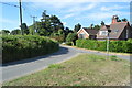
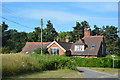
4

House near Harkstead Church
At the corner of Church Lane and Rectory Road.
Image: © Andrew Hill
Taken: 2 May 2009
0.07 miles
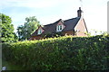
9
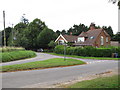
Junction near church
You can also see Minster Cottage at the junction of Fish Pond Hill and Rectory Road.
Image: © Roger Jones
Taken: 19 Jul 2011
0.08 miles