IMAGES TAKEN NEAR TO
Harkstead, IPSWICH, IP9 1BH
Introduction
This page details the photographs taken nearby to IP9 1BH by members of the Geograph project.
The Geograph project started in 2005 with the aim of publishing, organising and preserving representative images for every square kilometre of Great Britain, Ireland and the Isle of Man.

There are currently over 7.5m images from over14,400 individuals and you can help contribute to the project by visiting https://www.geograph.org.uk
Image Map
Images are licensed for reuse under creativecommons.org/licenses/by-sa/2.0
Notes
- Clicking on the map will re-center to the selected point.
- The higher the marker number, the further away the image location is from the centre of the postcode.
Image Listing (29 Images Found)
Images are licensed for reuse under creativecommons.org/licenses/by-sa/2.0
Image
Details
Distance
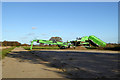
4
Farm machinery by Brick Kiln Lane
See also Image
Image: © N Chadwick
Taken: 23 Jun 2018
0.06 miles
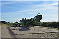
5
Impressive farm machinery
I think there are three units here, all by Miedema. Some sort of root crop input loading skip, a preparation machine (evidently cleaning off soil, at least) and an output loading elevator with a droop nose to avoid too much damage. Probably for sugar beet.
Image: © Robin Webster
Taken: 26 Nov 2017
0.07 miles
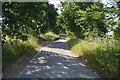
8
Hardstanding and concrete roadway off Brick Kiln Road
Image: © Adrian S Pye
Taken: 27 May 2015
0.10 miles