IMAGES TAKEN NEAR TO
The Street, IPSWICH, IP9 1AQ
Introduction
This page details the photographs taken nearby to The Street, IP9 1AQ by members of the Geograph project.
The Geograph project started in 2005 with the aim of publishing, organising and preserving representative images for every square kilometre of Great Britain, Ireland and the Isle of Man.

There are currently over 7.5m images from over14,400 individuals and you can help contribute to the project by visiting https://www.geograph.org.uk
Image Map
Images are licensed for reuse under creativecommons.org/licenses/by-sa/2.0
Notes
- Clicking on the map will re-center to the selected point.
- The higher the marker number, the further away the image location is from the centre of the postcode.
Image Listing (25 Images Found)
Images are licensed for reuse under creativecommons.org/licenses/by-sa/2.0
Image
Details
Distance
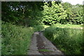
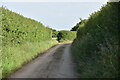
6
Curve in track
The track, running through farmland, is also a public footpath
Image: © Roger Jones
Taken: 17 Jul 2011
0.10 miles
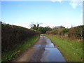
9
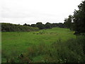
Field boundary
The hedge built upon the raised part of the landscape suggests an old and well established field boundary in this rolling part of the Suffolk countryside.
Seen from footpath near Freston Lodge Farm.
Image: © Roger Jones
Taken: 17 Jul 2011
0.12 miles