IMAGES TAKEN NEAR TO
Church Lane, IPSWICH, IP8 4PL
Introduction
This page details the photographs taken nearby to Church Lane, IP8 4PL by members of the Geograph project.
The Geograph project started in 2005 with the aim of publishing, organising and preserving representative images for every square kilometre of Great Britain, Ireland and the Isle of Man.

There are currently over 7.5m images from over14,400 individuals and you can help contribute to the project by visiting https://www.geograph.org.uk
Image Map
Images are licensed for reuse under creativecommons.org/licenses/by-sa/2.0
Notes
- Clicking on the map will re-center to the selected point.
- The higher the marker number, the further away the image location is from the centre of the postcode.
Image Listing (59 Images Found)
Images are licensed for reuse under creativecommons.org/licenses/by-sa/2.0
Image
Details
Distance
1
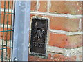
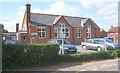
Ordnance Survey Flush Bracket S8107
This can be found on the wall of the school in Somersham.
For more detail see : http://www.bench-marks.org.uk/bm12640
Image: © Peter Wood
Taken: 24 Feb 2015
0.02 miles
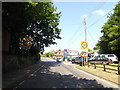
2
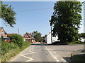
Church Lane, Somersham
At the junction with Church Close
Image: © Geographer
Taken: 8 Jun 2016
0.02 miles
3
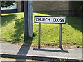
Church Close sign
On Church Close at the junction with Church Lane
Image: © Geographer
Taken: 8 Jun 2016
0.03 miles
4
Local garage
Local garage Somersham Suffolk.
Image: © Keith Evans
Taken: 21 Sep 2008
0.04 miles
7
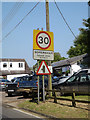
Somersham Village Name sign on Somersham Road
Image: © Geographer
Taken: 8 Jun 2016
0.04 miles
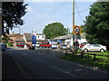
8
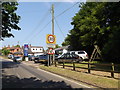
Somersham Garage & Somersham Village Name sign
Image: © Geographer
Taken: 8 Jun 2016
0.04 miles
10
Church Path to Church Lane
Near St Margaret's Church
Image: © Geographer
Taken: 8 Jun 2016
0.06 miles