IMAGES TAKEN NEAR TO
Church Acre, IPSWICH, IP8 4LL
Introduction
This page details the photographs taken nearby to Church Acre, IP8 4LL by members of the Geograph project.
The Geograph project started in 2005 with the aim of publishing, organising and preserving representative images for every square kilometre of Great Britain, Ireland and the Isle of Man.

There are currently over 7.5m images from over14,400 individuals and you can help contribute to the project by visiting https://www.geograph.org.uk
Image Map
Images are licensed for reuse under creativecommons.org/licenses/by-sa/2.0
Notes
- Clicking on the map will re-center to the selected point.
- The higher the marker number, the further away the image location is from the centre of the postcode.
Image Listing (65 Images Found)
Images are licensed for reuse under creativecommons.org/licenses/by-sa/2.0
Image
Details
Distance
3
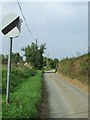
Broken road sign
Broken speed limit sign Flowton Suffolk.
Image: © Keith Evans
Taken: 21 Sep 2008
0.06 miles
4
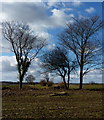
Field and trees near Flowton
Just north of the village looking west from the lane to Somersham.
Image: © Andrew Hill
Taken: 4 Mar 2010
0.07 miles
7
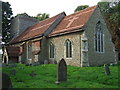
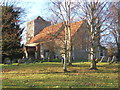
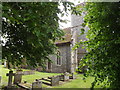
St Mary Flowton
The church of St Mary Flowton Suffolk for more info on the church see http://www.suffolkchurches.co.uk/flowton.html
Image: © Keith Evans
Taken: 21 Sep 2008
0.07 miles
9
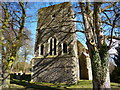
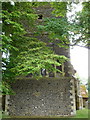
The tower of Flowton Church
A sturdy looking tower seen between the trees.
Image: © Andrew Hill
Taken: 4 Mar 2010
0.07 miles
10
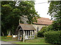
St.Mary's Church, Flowton
Off Flowton Road
http://www.suffolkchurches.co.uk/flowton.html
Image: © Geographer
Taken: 16 Jun 2016
0.07 miles