IMAGES TAKEN NEAR TO
Acton Road, IPSWICH, IP8 4HU
Introduction
This page details the photographs taken nearby to Acton Road, IP8 4HU by members of the Geograph project.
The Geograph project started in 2005 with the aim of publishing, organising and preserving representative images for every square kilometre of Great Britain, Ireland and the Isle of Man.

There are currently over 7.5m images from over14,400 individuals and you can help contribute to the project by visiting https://www.geograph.org.uk
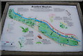
Image Map
Images are licensed for reuse under creativecommons.org/licenses/by-sa/2.0
Notes
- Clicking on the map will re-center to the selected point.
- The higher the marker number, the further away the image location is from the centre of the postcode.
Image Listing (54 Images Found)
Images are licensed for reuse under creativecommons.org/licenses/by-sa/2.0
Image
Details
Distance
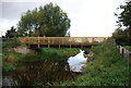
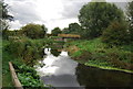
4
Footbridge over the river Gipping
Taking a path from Bramford village across to join the Gipping valley footpath.
Image: © Andrew Hill
Taken: 5 Apr 2009
0.09 miles
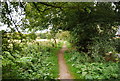

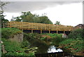
9
Footbridge over the River Gipping
Giving access to Bramford from the Gipping valley footpath.
Image: © Andrew Hill
Taken: 5 Apr 2009
0.10 miles
