IMAGES TAKEN NEAR TO
Chapel Field, IPSWICH, IP8 4HR
Introduction
This page details the photographs taken nearby to Chapel Field, IP8 4HR by members of the Geograph project.
The Geograph project started in 2005 with the aim of publishing, organising and preserving representative images for every square kilometre of Great Britain, Ireland and the Isle of Man.

There are currently over 7.5m images from over14,400 individuals and you can help contribute to the project by visiting https://www.geograph.org.uk
Image Map
Images are licensed for reuse under creativecommons.org/licenses/by-sa/2.0
Notes
- Clicking on the map will re-center to the selected point.
- The higher the marker number, the further away the image location is from the centre of the postcode.
Image Listing (60 Images Found)
Images are licensed for reuse under creativecommons.org/licenses/by-sa/2.0
Image
Details
Distance
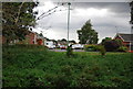
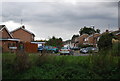
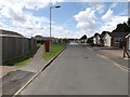
2
Broke Avenue, Bramford
At the junction with leggatt Drive
Image: © Geographer
Taken: 16 Jun 2016
0.06 miles
3
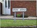
Broke Avenue sign
On Broke Avenue at the junction with Leggatt Drive
Image: © Geographer
Taken: 16 Jun 2016
0.07 miles
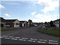
6
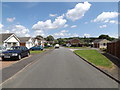
Leggatt Drive, Bramford
At the junction with Broke Avenue
Image: © Geographer
Taken: 16 Jun 2016
0.08 miles
9

79 Leggatt Drive Postbox
On Leggatt Drive
Postbox No.IP8 1408D
Image: © Geographer
Taken: 16 Jun 2016
0.08 miles
10
Leggatt Drive & 79 Leggatt Drive Postbox
Postbox No.IP8 1408D
Image: © Geographer
Taken: 16 Jun 2016
0.08 miles