IMAGES TAKEN NEAR TO
Tortoiseshell Close, IPSWICH, IP8 3QZ
Introduction
This page details the photographs taken nearby to Tortoiseshell Close, IP8 3QZ by members of the Geograph project.
The Geograph project started in 2005 with the aim of publishing, organising and preserving representative images for every square kilometre of Great Britain, Ireland and the Isle of Man.

There are currently over 7.5m images from over14,400 individuals and you can help contribute to the project by visiting https://www.geograph.org.uk
Image Map
Images are licensed for reuse under creativecommons.org/licenses/by-sa/2.0
Notes
- Clicking on the map will re-center to the selected point.
- The higher the marker number, the further away the image location is from the centre of the postcode.
Image Listing (60 Images Found)
Images are licensed for reuse under creativecommons.org/licenses/by-sa/2.0
Image
Details
Distance
1
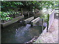
Belstead Brook Water Level Gauging Station
This is the flow gauging weir at Belstead Brook, 40 metres upstream of Belstead Bridge. It is a Compound Crump weir, that is, it is triangular in cross section with a precise triangular profile often used for discharge monitoring (after E S Crump, who defined the characteristics of this shape of weir). Normally a Crump weir will have a slope of 1:5 downstream and 1:2 upstream. This is a compound weir because it has a pair of flumes in the centre of the weir.
When used to measure the flow of water in open channels such as here at Belstead Brook, a flume is defined as a specially shaped, fixed hydraulic structure that under free-flow conditions forces flow to accelerate in such a manner that the flow rate through the flume can be characterized by a level-to-flow relationship as applied to a single head (level) measurement within the flume.The flow is measured by a float with a counterweight. This method requires a float to be installed in a well on the stream bank connected to the weir by a pipe. The well provides a stable environment undisturbed by wind or water movement for a small float attached to a moving line and a counter weight so the movement in stream level can be measured by rotation of a wheel. Typically the wheel rotation is measured very accurately by light or laser encoder, in the instrument.
A few metres away from the brook at this point is a cabinet of electrical equipment whereby the flow details are transmitted to the river authority monitoring centre.
Image: © Nigel Mykura
Taken: 23 Jun 2014
0.04 miles
2
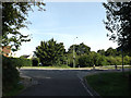
Bobbits Lane, Pinewood
At the junction with Ellenbrook Road
Image: © Geographer
Taken: 21 Aug 2014
0.04 miles
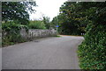
4
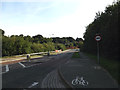
Ellenbrook Road, Pinewood, Ipswich
Looking towards Belstead Bridge at the junction with Bobbits Lane
Image: © Geographer
Taken: 21 Aug 2014
0.04 miles
5
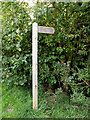
Footpath sign off Ellenbrook Road
At the junction with Bobbits Lane.
Image: © Geographer
Taken: 21 Aug 2014
0.04 miles
6
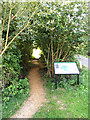
Footpath & Belstead Brook Park information board
Off Ellenbrook Road at the junction with Bobbits Lane
Image: © Geographer
Taken: 21 Aug 2014
0.04 miles
7
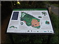
Belstead Brook Park information board
Off Ellenbrook Road at the junction with Bobbits Lane
(Close up)
Image: © Geographer
Taken: 21 Aug 2014
0.04 miles
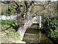
10
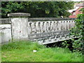
Old Belstead Bridge (1)
This old concrete bridge whose parapet was cracking badly is now disused for motor traffic and has been replaced by a more modern bridge along side.
See Image and Image
Image: © Nigel Mykura
Taken: 23 Jun 2014
0.05 miles