IMAGES TAKEN NEAR TO
Clay Hill, IPSWICH, IP8 3QL
Introduction
This page details the photographs taken nearby to Clay Hill, IP8 3QL by members of the Geograph project.
The Geograph project started in 2005 with the aim of publishing, organising and preserving representative images for every square kilometre of Great Britain, Ireland and the Isle of Man.

There are currently over 7.5m images from over14,400 individuals and you can help contribute to the project by visiting https://www.geograph.org.uk
Image Map
Images are licensed for reuse under creativecommons.org/licenses/by-sa/2.0
Notes
- Clicking on the map will re-center to the selected point.
- The higher the marker number, the further away the image location is from the centre of the postcode.
Image Listing (5 Images Found)
Images are licensed for reuse under creativecommons.org/licenses/by-sa/2.0
Image
Details
Distance
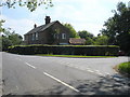
2
Farmhouse at Manor Farm
The road in front of the house is Duke Street.
Image: © Robert Edwards
Taken: 10 Nov 2006
0.13 miles
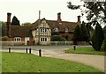
3
Manor Farm, Duke Street, Hintlesham
Image: © Humphrey Bolton
Taken: 12 Feb 2016
0.16 miles
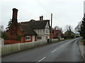
4
Leaving Hintlesham on Pond Hall Road for Hadleigh
Image: © Adrian S Pye
Taken: 19 Aug 2015
0.17 miles
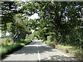
5
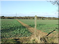
Footpath
Footpath and footpath sign near to Chattisham, Suffolk.
Image: © Keith Evans
Taken: 2 Feb 2012
0.25 miles