IMAGES TAKEN NEAR TO
Elmsett Road, IPSWICH, IP8 3NZ
Introduction
This page details the photographs taken nearby to Elmsett Road, IP8 3NZ by members of the Geograph project.
The Geograph project started in 2005 with the aim of publishing, organising and preserving representative images for every square kilometre of Great Britain, Ireland and the Isle of Man.

There are currently over 7.5m images from over14,400 individuals and you can help contribute to the project by visiting https://www.geograph.org.uk
Image Map
Images are licensed for reuse under creativecommons.org/licenses/by-sa/2.0
Notes
- Clicking on the map will re-center to the selected point.
- The higher the marker number, the further away the image location is from the centre of the postcode.
Image Listing (5 Images Found)
Images are licensed for reuse under creativecommons.org/licenses/by-sa/2.0
Image
Details
Distance
1
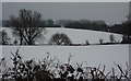
Snow covered fields
The fields are to the north of Hintlesham Priory, seen from the road between Aldham and Burstall.
Image: © Andrew Hill
Taken: 12 Jan 2010
0.07 miles
2
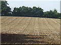
Lines in the field
Field near to Flowton Suffolk.
Image: © Keith Evans
Taken: 21 Sep 2008
0.10 miles
3
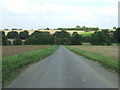
Junction down the hill
Looking north to the junction on the Elmsett to Flowton road near to Flowton Suffolk.
Image: © Keith Evans
Taken: 21 Sep 2008
0.17 miles
4
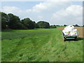
Green meadow
Meadow grass near to Flowton Suffolk.
Image: © Keith Evans
Taken: 21 Sep 2008
0.18 miles
5
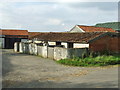
Old pig pens
Old pig pens Priory Farm near to Burstallhill, Suffolk.
Image: © Keith Evans
Taken: 28 Sep 2008
0.24 miles