IMAGES TAKEN NEAR TO
Priory Road, IPSWICH, IP8 3NX
Introduction
This page details the photographs taken nearby to Priory Road, IP8 3NX by members of the Geograph project.
The Geograph project started in 2005 with the aim of publishing, organising and preserving representative images for every square kilometre of Great Britain, Ireland and the Isle of Man.

There are currently over 7.5m images from over14,400 individuals and you can help contribute to the project by visiting https://www.geograph.org.uk
Image Map
Images are licensed for reuse under creativecommons.org/licenses/by-sa/2.0
Notes
- Clicking on the map will re-center to the selected point.
- The higher the marker number, the further away the image location is from the centre of the postcode.
Image Listing (3 Images Found)
Images are licensed for reuse under creativecommons.org/licenses/by-sa/2.0
Image
Details
Distance
1
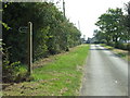
Road and footpath
Looking south east towards Northlands Farm with a footpath on the left near to Flowton Suffolk.
Image: © Keith Evans
Taken: 21 Sep 2008
0.08 miles
2
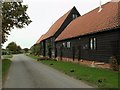
Northlands, near to Hintlesham, Suffolk
This is a converted barn and the barn was once part of Northland Farm.
Image: © Robert Edwards
Taken: 27 Sep 2006
0.08 miles
3
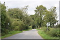
Priory Road, Hintlesham
Taken looking north from its junction with the A1071.
Image: © Trevor Harris
Taken: 2 Sep 2020
0.22 miles