IMAGES TAKEN NEAR TO
Oakfield Road, IPSWICH, IP8 3JS
Introduction
This page details the photographs taken nearby to Oakfield Road, IP8 3JS by members of the Geograph project.
The Geograph project started in 2005 with the aim of publishing, organising and preserving representative images for every square kilometre of Great Britain, Ireland and the Isle of Man.

There are currently over 7.5m images from over14,400 individuals and you can help contribute to the project by visiting https://www.geograph.org.uk
Image Map
Images are licensed for reuse under creativecommons.org/licenses/by-sa/2.0
Notes
- Clicking on the map will re-center to the selected point.
- The higher the marker number, the further away the image location is from the centre of the postcode.
Image Listing (12 Images Found)
Images are licensed for reuse under creativecommons.org/licenses/by-sa/2.0
Image
Details
Distance
1
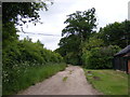
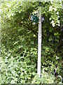
The Avenue footpath to London Road
Off Oakfield Road near Belstead Old Rectory
Image: © Geographer
Taken: 14 Jun 2013
0.02 miles
2
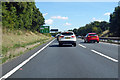
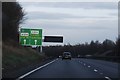
A12 towards Ipswich
Queuing up to the roundabout at the A14 junction.
Image: © Robin Webster
Taken: 11 Aug 2018
0.07 miles
3
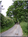
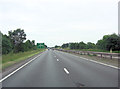
Oakfield Road
Looking towards Belstead Old Rectory near the footpath to Church Lane
Image: © Geographer
Taken: 14 Jun 2013
0.10 miles
4
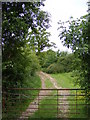
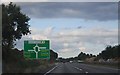
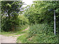
Footpath to Church Lane
Off Oakfield Road
Image: © Geographer
Taken: 14 Jun 2013
0.10 miles
5
Footpath to Church Lane
Off Oakfield Road
Image: © Geographer
Taken: 14 Jun 2013
0.11 miles