IMAGES TAKEN NEAR TO
Back Lane, IPSWICH, IP8 3JA
Introduction
This page details the photographs taken nearby to Back Lane, IP8 3JA by members of the Geograph project.
The Geograph project started in 2005 with the aim of publishing, organising and preserving representative images for every square kilometre of Great Britain, Ireland and the Isle of Man.

There are currently over 7.5m images from over14,400 individuals and you can help contribute to the project by visiting https://www.geograph.org.uk
Image Map
Images are licensed for reuse under creativecommons.org/licenses/by-sa/2.0
Notes
- Clicking on the map will re-center to the selected point.
- The higher the marker number, the further away the image location is from the centre of the postcode.
Image Listing (54 Images Found)
Images are licensed for reuse under creativecommons.org/licenses/by-sa/2.0
Image
Details
Distance
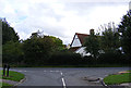
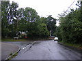
1
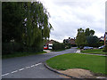
Back Lane, Washbrook
At the junction with Charlotte's
Image: © Geographer
Taken: 4 Oct 2013
0.07 miles
4
Back Lane, Washbrook
At the junction with Charlotte's
Image: © Geographer
Taken: 4 Oct 2013
0.08 miles
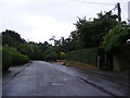
5
Charlotte's, Washbrook
At the junction with Back Lane
Image: © Geographer
Taken: 4 Oct 2013
0.08 miles
6
Charlotte's, Washbrook
At the junction with Back Lane
Image: © Geographer
Taken: 4 Oct 2013
0.08 miles
7
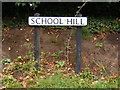
School Hill sign
On School Hill at the junction with Pheasant Rise
Image: © Geographer
Taken: 22 Aug 2013
0.08 miles
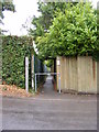
8
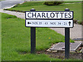
Charlottes sign
On Charlottes at the junction with Back Lane
Image: © Geographer
Taken: 4 Oct 2013
0.08 miles
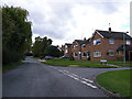
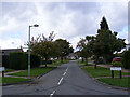
9
School Hill, Washbrook
Looking towards Copdock Primary School at the junction with Pheasant Rise
Image: © Geographer
Taken: 22 Aug 2013
0.09 miles
10
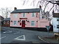
The Old Brook Inn
The Old Brook Inn pub and restaurant Washbrook, Suffolk.
Image: © Keith Evans
Taken: 27 Jan 2009
0.09 miles