IMAGES TAKEN NEAR TO
School Hill, IPSWICH, IP8 3HY
Introduction
This page details the photographs taken nearby to School Hill, IP8 3HY by members of the Geograph project.
The Geograph project started in 2005 with the aim of publishing, organising and preserving representative images for every square kilometre of Great Britain, Ireland and the Isle of Man.

There are currently over 7.5m images from over14,400 individuals and you can help contribute to the project by visiting https://www.geograph.org.uk
Image Map
Images are licensed for reuse under creativecommons.org/licenses/by-sa/2.0
Notes
- Clicking on the map will re-center to the selected point.
- The higher the marker number, the further away the image location is from the centre of the postcode.
Image Listing (61 Images Found)
Images are licensed for reuse under creativecommons.org/licenses/by-sa/2.0
Image
Details
Distance
1
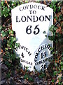
To London 65
Old cast iron milepost Washbrook, Suffolk. For overall view see http://www.geograph.org.uk/photo/1159446 For more info see http://milestones.megalithia.com/sites/tm117418.htm do look at their home page. This is one of a series of mileposts that follow the A12 see http://www.geograph.org.uk/search.php?i=5288637
Image: © Keith Evans
Taken: 12 Feb 2009
0.01 miles
2

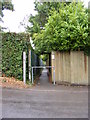
Ordnance Survey Flush Bracket S0902
This can be found on the wall of Copdock Primary School.
For more detail see : http://www.bench-marks.org.uk/bm11096
Image: © Peter Wood
Taken: 24 Feb 2015
0.02 miles
3
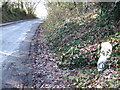
Old Cast Iron Milepost
Old cast iron milepost Washbrook, Suffolk. For close up view see http://www.geograph.org.uk/photo/1159443 and for more info on the post see http://milestones.megalithia.com/sites/tm117418.htm do look at their home page.
Image: © Keith Evans
Taken: 12 Feb 2009
0.03 miles
4
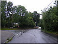
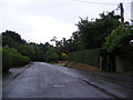
School Hill, Washbrook
Looking towards Copdock Primary School at the junction with Pheasant Rise
Image: © Geographer
Taken: 22 Aug 2013
0.03 miles
5
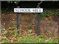
School Hill sign
On School Hill at the junction with Pheasant Rise
Image: © Geographer
Taken: 22 Aug 2013
0.04 miles
6
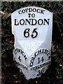
Old Milestone by The Street, Copdock
Metal plate attached to stone post by the UC road (was A12), in parish of COPDOCK AND WASHBROOK (BABERGH District), Copdock, under hedge. Erected by the Ipswich to Stratford St Mary turnpike trust in the 19th century.
Inscription reads:-
: IPSWICH / 4 / WOODBRIDGE / 11 : : COPDOCK / TO / LONDON / 65 : : COLCHESTER / 14 / CHELMSFORD / 36 :
Milestone Society National ID: SU_LI65.
Image: © R Mudhar & D Riseborough
Taken: 8 Dec 2010
0.05 miles