IMAGES TAKEN NEAR TO
Gipping Way, IPSWICH, IP8 3BE
Introduction
This page details the photographs taken nearby to Gipping Way, IP8 3BE by members of the Geograph project.
The Geograph project started in 2005 with the aim of publishing, organising and preserving representative images for every square kilometre of Great Britain, Ireland and the Isle of Man.

There are currently over 7.5m images from over14,400 individuals and you can help contribute to the project by visiting https://www.geograph.org.uk
Image Map
Images are licensed for reuse under creativecommons.org/licenses/by-sa/2.0
Notes
- Clicking on the map will re-center to the selected point.
- The higher the marker number, the further away the image location is from the centre of the postcode.
Image Listing (72 Images Found)
Images are licensed for reuse under creativecommons.org/licenses/by-sa/2.0
Image
Details
Distance
1
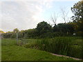
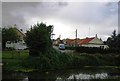
Across the Gipping to Broomfield Common
Broomfield Common is a street in Sproughton leading right down to the riverbank.
Image: © Andrew Hill
Taken: 8 Jan 2010
0.06 miles
2
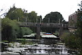
Broomfield Common across the Gipping
A similar photo can be seen in the snow. http://www.geograph.org.uk/photo/1653293
Image: © N Chadwick
Taken: 18 Sep 2011
0.06 miles
3
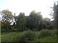
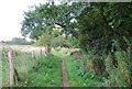
Trees at the River Gipping
From the Gipping Way.
Image: © Hamish Griffin
Taken: 21 Jul 2017
0.08 miles
4
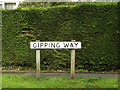
Gipping Way sign
On Gipping Way at the junction with Church Lane
Image: © Geographer
Taken: 1 Nov 2013
0.08 miles
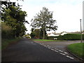
5
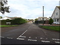
Gipping Way, Sproughton
At the junction with Church Lane
Image: © Geographer
Taken: 1 Nov 2013
0.09 miles
6
Church Lane, Sproughton
Looking towards Lower Street at the junction with Gipping Way
Image: © Geographer
Taken: 1 Nov 2013
0.09 miles