IMAGES TAKEN NEAR TO
Dux Street, IPSWICH, IP7 7QT
Introduction
This page details the photographs taken nearby to Dux Street, IP7 7QT by members of the Geograph project.
The Geograph project started in 2005 with the aim of publishing, organising and preserving representative images for every square kilometre of Great Britain, Ireland and the Isle of Man.

There are currently over 7.5m images from over14,400 individuals and you can help contribute to the project by visiting https://www.geograph.org.uk
Image Map
Images are licensed for reuse under creativecommons.org/licenses/by-sa/2.0
Notes
- Clicking on the map will re-center to the selected point.
- The higher the marker number, the further away the image location is from the centre of the postcode.
Image Listing (4 Images Found)
Images are licensed for reuse under creativecommons.org/licenses/by-sa/2.0
Image
Details
Distance
1
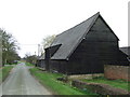
Black Barn
Barn at Ryece Hall Farm near to Brettenham, Suffolk.
Image: © Keith Evans
Taken: 6 Mar 2011
0.02 miles
2
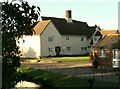
Ryece Hall Farm
Ryece Hall is a very ancient farm and was formerly part of the Abbey of St Edmund's estate.
Image: © Robert Edwards
Taken: 3 Nov 2006
0.04 miles
3
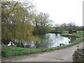
Farm Pond
Pond at Ryece Hall Farm near to Brettenham, Suffolk.
Image: © Keith Evans
Taken: 6 Mar 2011
0.04 miles
4
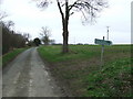
Footpath Sign
Footpath sign with destination details on Dux Street near to Brettenham, Suffolk.
Image: © Keith Evans
Taken: 6 Mar 2011
0.07 miles