IMAGES TAKEN NEAR TO
Beales Drive, IPSWICH, IP7 7QL
Introduction
This page details the photographs taken nearby to Beales Drive, IP7 7QL by members of the Geograph project.
The Geograph project started in 2005 with the aim of publishing, organising and preserving representative images for every square kilometre of Great Britain, Ireland and the Isle of Man.

There are currently over 7.5m images from over14,400 individuals and you can help contribute to the project by visiting https://www.geograph.org.uk
Image Map
Images are licensed for reuse under creativecommons.org/licenses/by-sa/2.0
Notes
- Clicking on the map will re-center to the selected point.
- The higher the marker number, the further away the image location is from the centre of the postcode.
Image Listing (20 Images Found)
Images are licensed for reuse under creativecommons.org/licenses/by-sa/2.0
Image
Details
Distance
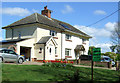
2
Bury Road, Mill Corner, Brettenham
Looking south west.
Image: © JThomas
Taken: 25 Apr 2017
0.06 miles
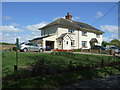
5
It's election time again
Green Party sign outside house, Mill Corner, Brettenham for the 2017 General Election.
Image: © JThomas
Taken: 25 Apr 2017
0.10 miles
7
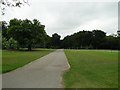
The Drive
The drive back to the road from Brettenham Old Hall (School)
Image: © Adrian S Pye
Taken: 18 Jun 2010
0.14 miles
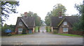
9
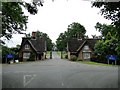
Lodges at the entrance to Old Buckenham Hall, Brettenham
The lodges are still used as living accommodation for staff at the Hall which is now a school.
Image: © Adrian S Pye
Taken: 18 Jun 2010
0.14 miles
10
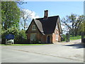
Lodge, Entrance to Old Buckenham Hall School, Thorpe Morieux
Image: © JThomas
Taken: 25 Apr 2017
0.15 miles