IMAGES TAKEN NEAR TO
Kettlebaston, IPSWICH, IP7 7QG
Introduction
This page details the photographs taken nearby to IP7 7QG by members of the Geograph project.
The Geograph project started in 2005 with the aim of publishing, organising and preserving representative images for every square kilometre of Great Britain, Ireland and the Isle of Man.

There are currently over 7.5m images from over14,400 individuals and you can help contribute to the project by visiting https://www.geograph.org.uk
Image Map
Images are licensed for reuse under creativecommons.org/licenses/by-sa/2.0
Notes
- Clicking on the map will re-center to the selected point.
- The higher the marker number, the further away the image location is from the centre of the postcode.
Image Listing (8 Images Found)
Images are licensed for reuse under creativecommons.org/licenses/by-sa/2.0
Image
Details
Distance
2
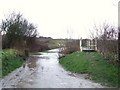
Ford
Ford and footbridge on farmers track near to Monks Eleigh, Suffolk.
Image: © Keith Evans
Taken: 27 Feb 2011
0.07 miles
3
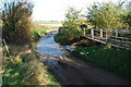
Ford at Wagger Farm, Monks Eleigh
This ford is found just into the entrance to Wagger Farm and the UCR to Kettlebaston.
Image: © John Walton
Taken: 8 Nov 2012
0.07 miles
4
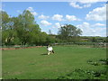
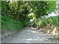
Highlands Road near Wagger Farm
Looking south east.
Image: © JThomas
Taken: 25 Apr 2017
0.08 miles
5
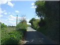
Monks Eleigh: Lane leading to Monks Eleigh
Image: © Michael Garlick
Taken: 28 Oct 2022
0.11 miles
6
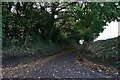
Narrow lane from Highlands Road to Monk's Eleigh
Image: © Adrian S Pye
Taken: 4 Jun 2015
0.13 miles
7
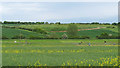
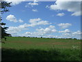
Looking to paddocks over oilseed rape, Monks Eleigh
In the distance are horses in paddocks in the parish of Kettlebaston, in the foreground is an oilseed rape field in the parish of Monks Eleigh. The parish boundary runs along the boundary of the arable land with the paddocks.
This photo is featured in the "Lavenham and backroads to Semer" geo-trip here: http://www.geograph.org.uk/geotrips/999
Image: © Roger Jones
Taken: 24 May 2015
0.17 miles