IMAGES TAKEN NEAR TO
Bury Road, IPSWICH, IP7 7PW
Introduction
This page details the photographs taken nearby to Bury Road, IP7 7PW by members of the Geograph project.
The Geograph project started in 2005 with the aim of publishing, organising and preserving representative images for every square kilometre of Great Britain, Ireland and the Isle of Man.

There are currently over 7.5m images from over14,400 individuals and you can help contribute to the project by visiting https://www.geograph.org.uk
Image Map
Images are licensed for reuse under creativecommons.org/licenses/by-sa/2.0
Notes
- Clicking on the map will re-center to the selected point.
- The higher the marker number, the further away the image location is from the centre of the postcode.
Image Listing (9 Images Found)
Images are licensed for reuse under creativecommons.org/licenses/by-sa/2.0
Image
Details
Distance
1
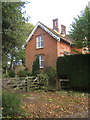
Hitcham Lodge by the lane to Brettenham
Image: © Andrew Hill
Taken: 27 Oct 2007
0.01 miles
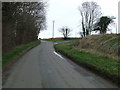
2
Bury Road
Bury Road looking east near to Brettenham, Suffolk.
Image: © Keith Evans
Taken: 6 Mar 2011
0.03 miles
3
Fields and trees by Hitcham / Brettenham lane
Image: © Andrew Hill
Taken: 27 Oct 2007
0.15 miles
4
Track through Devil's Hill Wood
This track, which is not a public footpath, leads northwards from Bury Road, near Castlehill.
Image: © Bob Jones
Taken: 15 Dec 2009
0.17 miles
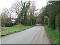
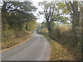
5
Road Junction
Road junction off Bury Road near to Brettenham, Suffolk.
Image: © Keith Evans
Taken: 6 Mar 2011
0.18 miles
6
Bury Road, lane to Hitcham from Brettenham
Named on OS 1:25,000 map.
Image: © Andrew Hill
Taken: 27 Oct 2007
0.20 miles
7
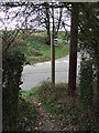
Footpath Sign
Footpath sign and Bury Road near to Brettenham, Suffolk.
Image: © Keith Evans
Taken: 6 Mar 2011
0.21 miles
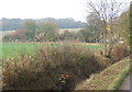
8
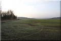
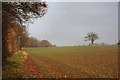
Farmland at Castlehill
The area between Brettenham and Kettlebaston is partly wooded, and elsewhere consists of large fields. Here, close to the farm at Castlehill, the field stretches into the distance, where two wooded areas, Thorn's Close and Bushey Ley, can be seen.
Image: © Bob Jones
Taken: 15 Dec 2009
0.22 miles
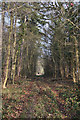
9
Footpath to Brettenham
The path leads northwards from Bury Road, following the edge of Devil's Hill Wood.
Image: © Bob Jones
Taken: 15 Dec 2009
0.22 miles