IMAGES TAKEN NEAR TO
Brettenham Road, IPSWICH, IP7 7NU
Introduction
This page details the photographs taken nearby to Brettenham Road, IP7 7NU by members of the Geograph project.
The Geograph project started in 2005 with the aim of publishing, organising and preserving representative images for every square kilometre of Great Britain, Ireland and the Isle of Man.

There are currently over 7.5m images from over14,400 individuals and you can help contribute to the project by visiting https://www.geograph.org.uk
Image Map
Images are licensed for reuse under creativecommons.org/licenses/by-sa/2.0
Notes
- Clicking on the map will re-center to the selected point.
- The higher the marker number, the further away the image location is from the centre of the postcode.
Image Listing (7 Images Found)
Images are licensed for reuse under creativecommons.org/licenses/by-sa/2.0
Image
Details
Distance
1
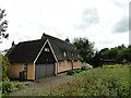
Thatched house on Cook's Green, Brettenham
Image: © Adrian S Pye
Taken: 1 Jun 2015
0.01 miles

3
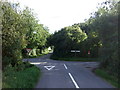
Road junction near Peppertree Farm
Hares Road meets Bugg's Lane.
Looking south.
Image: © JThomas
Taken: 14 Sep 2015
0.08 miles
5
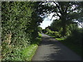
Hares Road
Heading south near Peppertree Farm.
Image: © JThomas
Taken: 14 Sep 2015
0.13 miles
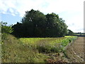
6
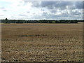
Stubble field near Peppertree Farm
West of Hares Lane.
Image: © JThomas
Taken: 14 Sep 2015
0.17 miles
7

I've got an old combine harvester
Old combine stored for the winter at Ennals Farm near to Cross Green, Suffolk.
Image: © Keith Evans
Taken: 13 Oct 2011
0.20 miles