IMAGES TAKEN NEAR TO
Battisford Road, IPSWICH, IP7 7LX
Introduction
This page details the photographs taken nearby to Battisford Road, IP7 7LX by members of the Geograph project.
The Geograph project started in 2005 with the aim of publishing, organising and preserving representative images for every square kilometre of Great Britain, Ireland and the Isle of Man.

There are currently over 7.5m images from over14,400 individuals and you can help contribute to the project by visiting https://www.geograph.org.uk
Image Map
Images are licensed for reuse under creativecommons.org/licenses/by-sa/2.0
Notes
- Clicking on the map will re-center to the selected point.
- The higher the marker number, the further away the image location is from the centre of the postcode.
Image Listing (6 Images Found)
Images are licensed for reuse under creativecommons.org/licenses/by-sa/2.0
Image
Details
Distance
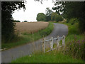
1
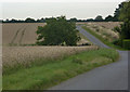
Lane near Laurels Farm
Heading through open fields towards Battisford.
Image: © Andrew Hill
Taken: 5 Aug 2009
0.04 miles
2
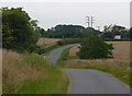
Lane west of Battisford
Dipping past Laurels Farm on the left.
Image: © Andrew Hill
Taken: 5 Aug 2009
0.08 miles
4
Minor road towards Battisford Tye
Heading east.
Image: © JThomas
Taken: 14 Sep 2015
0.17 miles
5
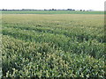
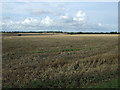
Suffolk wheatfields
Opposite Laurels Farm, looking north-west towards Millhill Farm.
Image: © Jonathan Billinger
Taken: 26 Jun 2007
0.17 miles
6
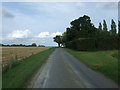
Lane towards Battisford
Any approach to Battisford from the B1115 seems very elusive. This is the most direct route from Hitcham.
Image: © Andrew Hill
Taken: 5 Aug 2009
0.24 miles