IMAGES TAKEN NEAR TO
Hitcham Road, IPSWICH, IP7 7LB
Introduction
This page details the photographs taken nearby to Hitcham Road, IP7 7LB by members of the Geograph project.
The Geograph project started in 2005 with the aim of publishing, organising and preserving representative images for every square kilometre of Great Britain, Ireland and the Isle of Man.

There are currently over 7.5m images from over14,400 individuals and you can help contribute to the project by visiting https://www.geograph.org.uk
Image Map
Images are licensed for reuse under creativecommons.org/licenses/by-sa/2.0
Notes
- Clicking on the map will re-center to the selected point.
- The higher the marker number, the further away the image location is from the centre of the postcode.
Image Listing (15 Images Found)
Images are licensed for reuse under creativecommons.org/licenses/by-sa/2.0
Image
Details
Distance
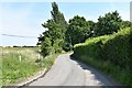
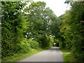
1
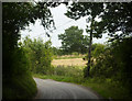
Lane emerging from trees
North of Wattisham village.
Image: © Andrew Hill
Taken: 5 Aug 2009
0.01 miles
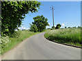
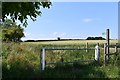
7
Into open fields
The lane to Bird Street twists and runs left to right immediately beyond the first field.
Image: © Andrew Hill
Taken: 5 Aug 2009
0.03 miles
8
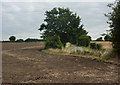
Harvested field
With a glimpse of the lane to Bird Street from Wattisham on the right.
Image: © Andrew Hill
Taken: 5 Aug 2009
0.04 miles
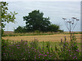
9
Lane through trees
North of Wattisham village, towards he B1115 between Hitcham and Great Finborough. There are still orchards around here.
Image: © Andrew Hill
Taken: 5 Aug 2009
0.06 miles
10
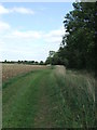
Wide Footpath
Looking east along this wide footpath near to Wattisham, Suffolk.
Image: © Keith Evans
Taken: 6 Sep 2009
0.15 miles