IMAGES TAKEN NEAR TO
Ipswich Road, IPSWICH, IP7 7BW
Introduction
This page details the photographs taken nearby to Ipswich Road, IP7 7BW by members of the Geograph project.
The Geograph project started in 2005 with the aim of publishing, organising and preserving representative images for every square kilometre of Great Britain, Ireland and the Isle of Man.

There are currently over 7.5m images from over14,400 individuals and you can help contribute to the project by visiting https://www.geograph.org.uk
Image Map
Images are licensed for reuse under creativecommons.org/licenses/by-sa/2.0
Notes
- Clicking on the map will re-center to the selected point.
- The higher the marker number, the further away the image location is from the centre of the postcode.
Image Listing (10 Images Found)
Images are licensed for reuse under creativecommons.org/licenses/by-sa/2.0
Image
Details
Distance
1
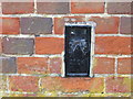
Ordnance Survey Flush Bracket 2104
This can be found on the wall of the Village Hall in Nedging Tye.
For more detail see : http://www.bench-marks.org.uk/bm2010
Image: © Peter Wood
Taken: 24 Feb 2015
0.01 miles
2
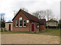
The Village Hall at Neging Tye
Viewed from the south-east.
Image: © Peter Wood
Taken: 24 Feb 2015
0.01 miles
3
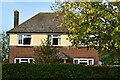
Nedging Tye, Ipswich Road: 'The Homestead'
Image: © Michael Garlick
Taken: 28 Oct 2022
0.06 miles
4
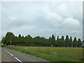
The eastern side of Nedging Tye
The trees screen the grounds of a house beside the B1078; beyond is the communications mast on the edge of the village
Image: © David Smith
Taken: 19 Jun 2014
0.07 miles
5
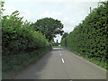
B1078 north of Cooper's Farm
The road-sign ahead is emblazoned Nedging with Naughton. Hmmm!
Image: © Stuart Logan
Taken: 28 Jun 2013
0.12 miles
6
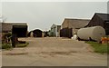
Tye Farm as viewed from Nedging Road
Image: © Robert Edwards
Taken: 10 Nov 2006
0.17 miles
7
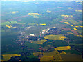
Former RAF Wattisham from the air
Closed as an RAF base in 1993, now used as an airfield by the army.
Click on this http://en.wikipedia.org/wiki/RAF_Wattisham to go to the wikipedia article about RAF Wattisham.
Image: © Thomas Nugent
Taken: 6 May 2011
0.21 miles
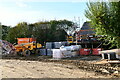
8
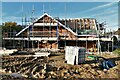
Nedging Tye, soon to be called Crowcroft Meadows: Bungalow under construction
Image: © Michael Garlick
Taken: 28 Oct 2022
0.22 miles
9
Nedging Tye, soon to be called Crowcroft Meadows: Bungalow under construction
Image: © Michael Garlick
Taken: 28 Oct 2022
0.23 miles
10
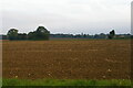
Field south of the lane, Nedging Tye
Image: © Christopher Hilton
Taken: 17 Sep 2023
0.25 miles