IMAGES TAKEN NEAR TO
Drury Lane, IPSWICH, IP7 7AQ
Introduction
This page details the photographs taken nearby to Drury Lane, IP7 7AQ by members of the Geograph project.
The Geograph project started in 2005 with the aim of publishing, organising and preserving representative images for every square kilometre of Great Britain, Ireland and the Isle of Man.

There are currently over 7.5m images from over14,400 individuals and you can help contribute to the project by visiting https://www.geograph.org.uk
Image Map
Images are licensed for reuse under creativecommons.org/licenses/by-sa/2.0
Notes
- Clicking on the map will re-center to the selected point.
- The higher the marker number, the further away the image location is from the centre of the postcode.
Image Listing (4 Images Found)
Images are licensed for reuse under creativecommons.org/licenses/by-sa/2.0
Image
Details
Distance
1
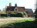
Serens Hall
Serens Hall near to Milden, Suffolk.
Image: © Keith Evans
Taken: 29 Sep 2011
0.09 miles
2
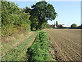
Pound Lane
Looking east along Pound Lane towards Serens Hall near to Milden, Suffolk.
Image: © Keith Evans
Taken: 29 Sep 2011
0.10 miles
3
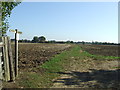
Footpath
Footpath and footpath sign near to Milden, Suffolk.
Image: © Keith Evans
Taken: 29 Sep 2011
0.14 miles
4
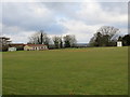
Milden Cricket Field
Viewed from the Triangulation Pillar at the south-east corner of the field.
Image: © Peter Wood
Taken: 21 Feb 2015
0.22 miles