IMAGES TAKEN NEAR TO
Hadleigh Road, IPSWICH, IP7 6QT
Introduction
This page details the photographs taken nearby to Hadleigh Road, IP7 6QT by members of the Geograph project.
The Geograph project started in 2005 with the aim of publishing, organising and preserving representative images for every square kilometre of Great Britain, Ireland and the Isle of Man.

There are currently over 7.5m images from over14,400 individuals and you can help contribute to the project by visiting https://www.geograph.org.uk
Image Map
Images are licensed for reuse under creativecommons.org/licenses/by-sa/2.0
Notes
- Clicking on the map will re-center to the selected point.
- The higher the marker number, the further away the image location is from the centre of the postcode.
Image Listing (8 Images Found)
Images are licensed for reuse under creativecommons.org/licenses/by-sa/2.0
Image
Details
Distance
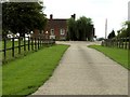
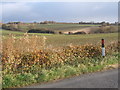
2
The Hadleigh road south of Whatfield, near Barrard's Hall
Image: © Andrew Hill
Taken: 23 Nov 2007
0.07 miles
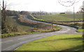
3
Road to Whatfield past farm buildings near Barrard's Hall
Image: © Andrew Hill
Taken: 23 Nov 2007
0.07 miles
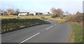
4
View along the road to Hadleigh from Whatfield
Looking into the next square south.
Image: © Andrew Hill
Taken: 23 Nov 2007
0.08 miles
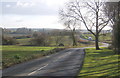
5
Country south of Whatfield, looking east
Image: © Andrew Hill
Taken: 23 Nov 2007
0.13 miles
6
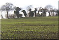
Field and line of trees, south of Whatfield
Image: © Andrew Hill
Taken: 23 Nov 2007
0.15 miles
7
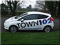
Town 102 FM
Car badge up for advertising one of the local radio stations of Town 102 FM seen at Whatfield, Suffolk.
Image: © Keith Evans
Taken: 29 Jan 2012
0.20 miles
8
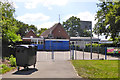
Whatfield CEVC Primary School
Basketball equipment advertising Adidas - nothing like inculcating brand snobbishness at an early age.
Image: © Robin Webster
Taken: 17 Jun 2017
0.24 miles