IMAGES TAKEN NEAR TO
Church Farm Place, IPSWICH, IP7 6QQ
Introduction
This page details the photographs taken nearby to Church Farm Place, IP7 6QQ by members of the Geograph project.
The Geograph project started in 2005 with the aim of publishing, organising and preserving representative images for every square kilometre of Great Britain, Ireland and the Isle of Man.

There are currently over 7.5m images from over14,400 individuals and you can help contribute to the project by visiting https://www.geograph.org.uk
Image Map
Images are licensed for reuse under creativecommons.org/licenses/by-sa/2.0
Notes
- Clicking on the map will re-center to the selected point.
- The higher the marker number, the further away the image location is from the centre of the postcode.
Image Listing (9 Images Found)
Images are licensed for reuse under creativecommons.org/licenses/by-sa/2.0
Image
Details
Distance
2
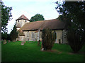
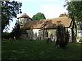
Whatfield St Margaret of Antioch?s church
This little church lost the top of its tower in the 17th century when it became ruinous. It now has a tiled pyramidal cap and an external stair turret leading to the belfry. A sundial on the Tudor porch is now in the shadow of trees. A sundial on the inside of the porch is dated 1844, obviously later than the porch! Its purpose is not fully understood. The nave roof has tie-beams and octagonal king-posts whereas the chancel has a lovely wagon roof with faces at the intersections. The octagonal font is plain with eight octagonal columns round a central shaft. Above is a western gallery housing the organ. The simple square Stuart pulpit retains its back and sounding board. There is a simple cusped piscina is in the chancel and below it is a 13th century coffin slab or lid with raised decoration; another is placed on the opposite side of the chancel. A wall plaque to William Vesey is dated 1699.
Image: © Adrian S Pye
Taken: 30 Aug 2007
0.17 miles
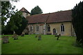
3
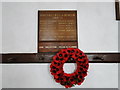
The War Memorial at Whatfield
The memorial covers three conflicts. In WW1 ten men were lost. In WW2 two men were lost and in the troubles in Palestine in 1948, one man was lost.
The WW1 Roll of Honour http://www.geograph.org.uk/photo/4632256 tells a different story where only five men are marked as lost.
Image: © Adrian S Pye
Taken: 25 Aug 2015
0.18 miles
4
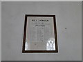
Whatfield Roll of Honour
There are only five names marked as fallen whereas the memorial names ten.
http://www.geograph.org.uk/photo/4632251
Image: © Adrian S Pye
Taken: 25 Aug 2015
0.18 miles
5
St. Margarets Whatfield
St.Margarets church Whatfield Suffolk. For more info on this church see http://suffolkchurches.co.uk/whatfield.html
Image: © Keith Evans
Taken: 18 Oct 2007
0.18 miles
7
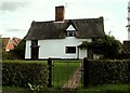
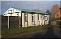
Farmhouse at Street Farm, Whatfield, Suffolk
Image: © Robert Edwards
Taken: 30 Aug 2006
0.19 miles
8

Farm Building
Farm building at Furneaux Farm near to Whatfield, Suffolk.
Image: © Keith Evans
Taken: 13 Feb 2011
0.20 miles
9
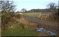
Gateway and path away from Furneaux Farm
Image: © Andrew Hill
Taken: 6 Dec 2008
0.23 miles