IMAGES TAKEN NEAR TO
The Street, IPSWICH, IP7 6PE
Introduction
This page details the photographs taken nearby to The Street, IP7 6PE by members of the Geograph project.
The Geograph project started in 2005 with the aim of publishing, organising and preserving representative images for every square kilometre of Great Britain, Ireland and the Isle of Man.

There are currently over 7.5m images from over14,400 individuals and you can help contribute to the project by visiting https://www.geograph.org.uk
Image Map
Images are licensed for reuse under creativecommons.org/licenses/by-sa/2.0
Notes
- Clicking on the map will re-center to the selected point.
- The higher the marker number, the further away the image location is from the centre of the postcode.
Image Listing (25 Images Found)
Images are licensed for reuse under creativecommons.org/licenses/by-sa/2.0
Image
Details
Distance
1
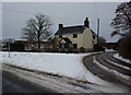
Lane junction and house near Elmsett
The lane to Offton on the left, right for Flowton. Seen with snow on the ground.
Image: © Andrew Hill
Taken: 12 Jan 2010
0.01 miles
2
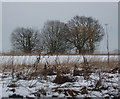
Wintry scene near Elmsett
Field and trees with snow by the lane to Flowton.
Image: © Andrew Hill
Taken: 12 Jan 2010
0.05 miles
3
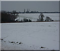
Fields by the Offton road
View across the open fields in the square in snowy conditions.
Image: © Andrew Hill
Taken: 12 Jan 2010
0.11 miles
4
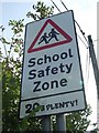
20s Plenty
School safety sign Elmsett, Suffolk.
Image: © Keith Evans
Taken: 28 Sep 2008
0.17 miles
5
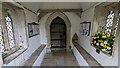
Church of St Peter, Elmsett Door and Porch Interior
https://historicengland.org.uk/listing/the-list/list-entry/1194594?section=official-list-entry
Image: © Sandy Gerrard
Taken: 12 Apr 2023
0.17 miles
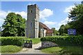
6
Church of St Peter, Elmsett
https://historicengland.org.uk/listing/the-list/list-entry/1194594?section=official-list-entry
Image: © Sandy Gerrard
Taken: 12 Apr 2023
0.17 miles
7
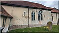
Blocked Norman Window at Church of St Peter, Elmsett
https://historicengland.org.uk/listing/the-list/list-entry/1194594?section=official-list-entry
Image: © Sandy Gerrard
Taken: 12 Apr 2023
0.17 miles
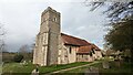
8
Elmsett church
St. Peter's is a grade I listed building from the 13th, 14th and 15th centuries.
Image: © Robin Webster
Taken: 17 Jun 2017
0.18 miles
9
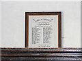
The Roll of Honour and War Memorial at Elmsett church
The Roll of Honour is placed in the organ gallery which is inaccessible unless you stand on a pew with a telephoto lens.
Those that failed to return are marked but can be read on the memorial: http://www.geograph.org.uk/photo/4419398
Image: © Adrian S Pye
Taken: 8 Apr 2015
0.18 miles
10
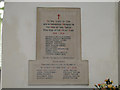
War Memorial in Elmsett church
The memorial names 11 men killed in Action in WW1. The lower plaque contains the names of 10 civilians killed.
The following is from the webpage of Elmsett school:
It was the 12th May 1941. Mr. Westren was cycling through the village on fire watch duty. Just after midnight the searchlights caught a German plane. The pilot was so scared of being shot down he dropped a 200lb bomb onto Elmsett. Mr.Westren was an eyewitness of this event.
Once he had got over the shock of a bomb landing right in front of him, he looked up and saw a girls head emerge through the top of a thatched roof! Mr. Westren climbed onto the roof and saved her. He took her to the Rose and Crown.
Unfortunately ten people died and eight houses were destroyed. http://www.elmsettschool.ik.org/news/11262255570.ikml
Image: © Adrian S Pye
Taken: 8 Apr 2015
0.18 miles