IMAGES TAKEN NEAR TO
Castle Road, IPSWICH, IP7 6JN
Introduction
This page details the photographs taken nearby to Castle Road, IP7 6JN by members of the Geograph project.
The Geograph project started in 2005 with the aim of publishing, organising and preserving representative images for every square kilometre of Great Britain, Ireland and the Isle of Man.

There are currently over 7.5m images from over14,400 individuals and you can help contribute to the project by visiting https://www.geograph.org.uk
Image Map
Images are licensed for reuse under creativecommons.org/licenses/by-sa/2.0
Notes
- Clicking on the map will re-center to the selected point.
- The higher the marker number, the further away the image location is from the centre of the postcode.
Image Listing (19 Images Found)
Images are licensed for reuse under creativecommons.org/licenses/by-sa/2.0
Image
Details
Distance
1
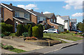
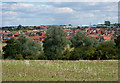
Houses on Castle Road
At the northwestern corner of Hadleigh.
Image: © Andrew Hill
Taken: 11 Aug 2009
0.06 miles
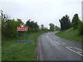
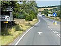
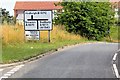
4
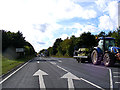
A1071 Ipswich Road, Hadleigh
At the junction with the A1141 Stone Street
Image: © Geographer
Taken: 4 Oct 2013
0.15 miles
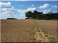
5
Fields by the River Brett with new housing beyond
The river flows left to right by the trees in the dip. The town has expanded northwards to fill in space towards the A1071.
Image: © Andrew Hill
Taken: 11 Aug 2009
0.16 miles
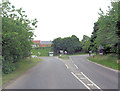
8
Footpath from Hadleigh
Crossing a field towards the A1071 which is in a cutting behind the hedge.
Image: © Andrew Hill
Taken: 11 Aug 2009
0.19 miles
10
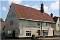
White Hart, 46 Bridge Street, Hadleigh
Grade II* Listed late 15th or early 16th century public house. Victuallers are list from 1791. It was recorded in the 1881 census as White Star but had been listed in 1865 as the White Hart. Carrying the Tolly Cobbold name, the pub appears in their agreements in 1924 and 1961. More recently it appears to have had a chequered history. Owners Punch Taverns put the pub on the market in 2012. Still unsold in August 2014 the pub stopped serving food and a week later unexpectedly closed only to open a week or two after that under new management. The White Hart Hadleigh Ltd was incorporated in January 2015 presumably when sold by Punch Taverns. In November 2016 it was reported that 'The pub has been closed for a couple of months. Apparently it does occasionally reopen for private parties'. Currently (2017) it is a 'restaurant pub' offering accommodation, catering and weddings. Directory entries include; 1839 Thomas Mott; 1855 William Mott (& cattle dealer); 1869 Thomas Last; 1891-1892 George Clarke; 1900 Mrs Ellen Clarke; 1901 no victualler given; 1912 Robert Thomas Clarke.
Image: © Jo and Steve Turner
Taken: 17 Jun 2017
0.20 miles