IMAGES TAKEN NEAR TO
Church Lane, IPSWICH, IP7 6JD
Introduction
This page details the photographs taken nearby to Church Lane, IP7 6JD by members of the Geograph project.
The Geograph project started in 2005 with the aim of publishing, organising and preserving representative images for every square kilometre of Great Britain, Ireland and the Isle of Man.

There are currently over 7.5m images from over14,400 individuals and you can help contribute to the project by visiting https://www.geograph.org.uk
Image Map
Images are licensed for reuse under creativecommons.org/licenses/by-sa/2.0
Notes
- Clicking on the map will re-center to the selected point.
- The higher the marker number, the further away the image location is from the centre of the postcode.
Image Listing (30 Images Found)
Images are licensed for reuse under creativecommons.org/licenses/by-sa/2.0
Image
Details
Distance
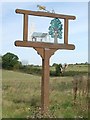
2
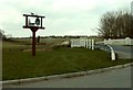
Village sign, Semer, Suffolk
The road over the bridge is the B1115.
Image: © Robert Edwards
Taken: 12 Apr 2006
0.06 miles
3
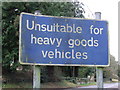
Road Sign
Road sign near to Semer, Suffolk.
Image: © Keith Evans
Taken: 13 Feb 2011
0.06 miles
5
Semer village sign
Semer village sign Semer Suffolk.
Image: © Keith Evans
Taken: 18 Oct 2007
0.08 miles
6
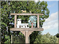
Semer village sign
The Semer sign if a frame but is surmounted by a ploughman and his horse reminiscent of the days when farming was reliant on horse and man power. Within the frame is the church of All Saints accompanied by the Semer tree, as it is in the churchyard. http://www.geograph.org.uk/photo/4631818
Image: © Adrian S Pye
Taken: 25 Aug 2015
0.08 miles
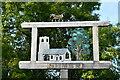
7
Semer village sign and Semer Bridge in the background
The Semer sign if a frame but is surmounted by a ploughman and his horse reminiscent of the days when farming was reliant on horse and man power. Within the frame is the church of All Saints accompanied by the Semer tree, as it is in the churchyard. http://www.geograph.org.uk/photo/4631814
Image: © Adrian S Pye
Taken: 25 Aug 2015
0.09 miles
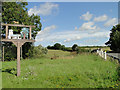
9
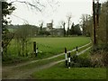
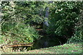
Church Meadow, Semer, Suffolk
This picture shows All Saints church at the back of Church Meadow.
Image: © Robert Edwards
Taken: 12 Apr 2006
0.09 miles
10
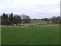
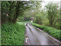
Road And Countryside
The B1115 and countryside near to Semar, Suffolk.
Image: © Keith Evans
Taken: 13 Feb 2011
0.10 miles