IMAGES TAKEN NEAR TO
Semer, IPSWICH, IP7 6HS
Introduction
This page details the photographs taken nearby to IP7 6HS by members of the Geograph project.
The Geograph project started in 2005 with the aim of publishing, organising and preserving representative images for every square kilometre of Great Britain, Ireland and the Isle of Man.

There are currently over 7.5m images from over14,400 individuals and you can help contribute to the project by visiting https://www.geograph.org.uk
Image Map
Images are licensed for reuse under creativecommons.org/licenses/by-sa/2.0
Notes
- Clicking on the map will re-center to the selected point.
- The higher the marker number, the further away the image location is from the centre of the postcode.
Image Listing (4 Images Found)
Images are licensed for reuse under creativecommons.org/licenses/by-sa/2.0
Image
Details
Distance
1

Minor road, Drakestone Green
Looking south east.
Image: © JThomas
Taken: 25 Apr 2017
0.07 miles
4
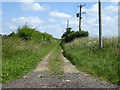
Public track towards Sayer's Farm
Mapped as a road with some unspecified restriction on use, but nothing on the ground to say what that was.
Image: © Robin Webster
Taken: 17 Jun 2017
0.13 miles