1
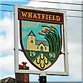
House, lane junction and village sign, Whatfield
Image: © Andrew Hill
Taken: 23 Nov 2007
0.05 miles
2
Whatfield village sign
Whatfield village sign Whatfield Suffolk.
Image: © Keith Evans
Taken: 18 Oct 2007
0.05 miles
3
Whatfield CEVC Primary School
Basketball equipment advertising Adidas - nothing like inculcating brand snobbishness at an early age.
Image: © Robin Webster
Taken: 17 Jun 2017
0.06 miles
4
Finger Post
Finger post Whatfield Suffolk.
Image: © Keith Evans
Taken: 18 Oct 2007
0.06 miles
5
Whatfield village sign (detail)
The Whatfield sign is the shape of a shield in a square frame. The church of St Margaret with its short tower and pyramidal roof is depicted with some stalks of wheat which represent not only the agricultural heritage of the parish but the origin of the name, “wheat-field” . Below are four horseshoes which recall the blacksmith who was also the local publican of The Four Horseshoes, public house, which still stands in The Street but is now a private residence. The sign was erected in 1990 according to the date thereon.
https://www.geograph.org.uk/photo/4295643 https://www.geograph.org.uk/photo/4295639
Image: © Adrian S Pye
Taken: 27 Apr 2015
0.07 miles
6
Whatfield village sign
The Whatfield sign is the shape of a shield in a square frame. The church of St Margaret with its short tower and pyramidal roof is depicted with some stalks of wheat which represent not only the agricultural heritage of the parish but the origin of the name, “wheat-field” . Below are four horseshoes which recall the blacksmith who was also the local publican of The Four Horseshoes, public house, which still stands in The Street but is now a private residence. The sign was erected in 1990 according to the date thereon.
http://www.geograph.org.uk/photo/4295643
Image: © Adrian S Pye
Taken: 8 Oct 2008
0.08 miles
7
Whatfield village sign (detail)
The Whatfield sign is the shape of a shield in a square frame. The church of St Margaret with its short tower and pyramidal roof is depicted with some stalks of wheat which represent not only the agricultural heritage of the parish but the origin of the name, “wheat-field” . Below are four horseshoes which recall the blacksmith who was also the local publican of The Four Horseshoes, public house, which still stands in The Street but is now a private residence. The sign was erected in 1990 according to the date thereon.
https://www.geograph.org.uk/photo/4295639
Image: © Adrian S Pye
Taken: 8 Oct 2008
0.08 miles
8
Direction Sign ? Signpost
Located on the green at the centre of the junction of Whatfield Road, Semer Road and The Street in Whatfield parish. 3 arms and spear & ball finial. See also http://www.flickr.com/photos/13171205@N08/8311495699.
Milestone Society National ID: SU_TM0246
Image: © Sam HM
Taken: 14 Apr 2020
0.08 miles
9
Whatfield village sign
Image: © Bikeboy
Taken: 7 Aug 2018
0.08 miles
10
Town 102 FM
Car badge up for advertising one of the local radio stations of Town 102 FM seen at Whatfield, Suffolk.
Image: © Keith Evans
Taken: 29 Jan 2012
0.11 miles


