IMAGES TAKEN NEAR TO
Wickerstreet Green, IPSWICH, IP7 6EY
Introduction
This page details the photographs taken nearby to Wickerstreet Green, IP7 6EY by members of the Geograph project.
The Geograph project started in 2005 with the aim of publishing, organising and preserving representative images for every square kilometre of Great Britain, Ireland and the Isle of Man.

There are currently over 7.5m images from over14,400 individuals and you can help contribute to the project by visiting https://www.geograph.org.uk
Image Map
Images are licensed for reuse under creativecommons.org/licenses/by-sa/2.0
Notes
- Clicking on the map will re-center to the selected point.
- The higher the marker number, the further away the image location is from the centre of the postcode.
Image Listing (7 Images Found)
Images are licensed for reuse under creativecommons.org/licenses/by-sa/2.0
Image
Details
Distance
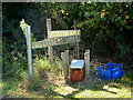
1
Footpath
Footpath sign that's also become the village notice board at Wicker Street Green, Suffolk.
Image: © Keith Evans
Taken: 30 Sep 2010
0.07 miles
2
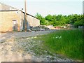
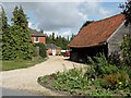
Barn at Redhouse Farm, Wicker Street Green
Image: © Oliver Dixon
Taken: 8 Jun 2006
0.13 miles
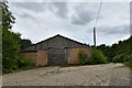
3
Blessem Hall sign
Home made sign at the start of the footpath which is also part of the driveway to the house.
Image: © Andrew Hill
Taken: 5 Sep 2009
0.15 miles
5
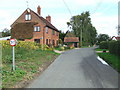
Wicker Street Green
Looking north east along the main street at Wicker Street Green, Suffolk.
Image: © Keith Evans
Taken: 30 Sep 2010
0.16 miles
7
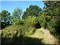
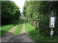
Track to Wicker Street Green
The footpath is enclosed for some distance.
Image: © Andrew Hill
Taken: 5 Sep 2009
0.20 miles