IMAGES TAKEN NEAR TO
Kersey, IPSWICH, IP7 6EU
Introduction
This page details the photographs taken nearby to IP7 6EU by members of the Geograph project.
The Geograph project started in 2005 with the aim of publishing, organising and preserving representative images for every square kilometre of Great Britain, Ireland and the Isle of Man.

There are currently over 7.5m images from over14,400 individuals and you can help contribute to the project by visiting https://www.geograph.org.uk
Image Map
Images are licensed for reuse under creativecommons.org/licenses/by-sa/2.0
Notes
- Clicking on the map will re-center to the selected point.
- The higher the marker number, the further away the image location is from the centre of the postcode.
Image Listing (12 Images Found)
Images are licensed for reuse under creativecommons.org/licenses/by-sa/2.0
Image
Details
Distance
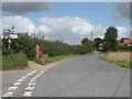
3
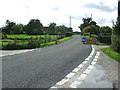
Country Road
Country road leading to Kersey Tye, Suffolk.
Image: © Keith Evans
Taken: 30 Sep 2010
0.08 miles
4
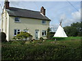
House And Wigwam
House with a Wigwam in the garden Hadleigh Heath, Suffolk.
Image: © Keith Evans
Taken: 30 Sep 2010
0.10 miles
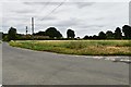
5
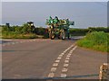
Cropsprayer takes to the road
At William's Green, near Kersey
Image: © Oliver Dixon
Taken: 8 Jun 2006
0.11 miles
6
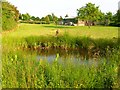
Pond and barn, near William's Green, Kersey
Image: © Oliver Dixon
Taken: 8 Jun 2006
0.12 miles
7
Long Delay
Roadworks signs out because of telecom cable work a little way down the road at Hadleigh Heath, Suffolk see http://www.geograph.org.uk/photo/2097024
Image: © Keith Evans
Taken: 30 Sep 2010
0.12 miles
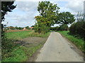
8
Kersey Tye
A hamlet in the Suffolk countryside.
Image: © Oliver Dixon
Taken: 8 Jun 2006
0.17 miles
9
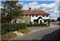
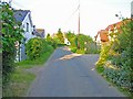
Houses at Kersey Tye
There is a cluster of houses and cottages at Kersey Tye on the lane between Kersey Upland and Castling's Heath.
Image: © Andrew Hill
Taken: 5 Sep 2009
0.20 miles
