IMAGES TAKEN NEAR TO
Kersey, IPSWICH, IP7 6EL
Introduction
This page details the photographs taken nearby to IP7 6EL by members of the Geograph project.
The Geograph project started in 2005 with the aim of publishing, organising and preserving representative images for every square kilometre of Great Britain, Ireland and the Isle of Man.

There are currently over 7.5m images from over14,400 individuals and you can help contribute to the project by visiting https://www.geograph.org.uk
Image Map
Images are licensed for reuse under creativecommons.org/licenses/by-sa/2.0
Notes
- Clicking on the map will re-center to the selected point.
- The higher the marker number, the further away the image location is from the centre of the postcode.
Image Listing (12 Images Found)
Images are licensed for reuse under creativecommons.org/licenses/by-sa/2.0
Image
Details
Distance
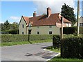
1
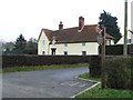
West Samson Hall
West Samson Hall near to Kersey, Suffolk.
Image: © Keith Evans
Taken: 29 Jan 2012
0.01 miles

3
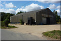
Barn opposite Sampson's Hall
A large corrugated metal construction.
Image: © Andrew Hill
Taken: 5 Sep 2009
0.05 miles
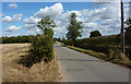
4

Minor road near Sampson's Hall
Looking south west.
Image: © JThomas
Taken: 25 Apr 2017
0.08 miles
5
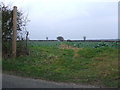
Footpath
Footpath across a field near to Kersey, Suffolk.
Image: © Keith Evans
Taken: 29 Jan 2012
0.15 miles
7
West Sampson's Hall at Kersey Upland
Image: © Robert Edwards
Taken: 30 Aug 2010
0.15 miles
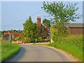
8
Lane towards Kersey
Viewpoint close to Sampson's Hall.
Image: © Andrew Hill
Taken: 5 Sep 2009
0.17 miles
9
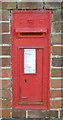
Edward VII postbox, West Sampson's Hall
Postbox No. IP7 1170.
See Image] for context.
Image: © JThomas
Taken: 25 Apr 2017
0.18 miles
10
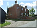
House, West Sampson's Hall
Showing position of Postbox No. IP7 1170.
See Image] for postbox.
Image: © JThomas
Taken: 25 Apr 2017
0.19 miles