IMAGES TAKEN NEAR TO
Rands Road, IPSWICH, IP7 5RN
Introduction
This page details the photographs taken nearby to Rands Road, IP7 5RN by members of the Geograph project.
The Geograph project started in 2005 with the aim of publishing, organising and preserving representative images for every square kilometre of Great Britain, Ireland and the Isle of Man.

There are currently over 7.5m images from over14,400 individuals and you can help contribute to the project by visiting https://www.geograph.org.uk
Image Map
Images are licensed for reuse under creativecommons.org/licenses/by-sa/2.0
Notes
- Clicking on the map will re-center to the selected point.
- The higher the marker number, the further away the image location is from the centre of the postcode.
Image Listing (4 Images Found)
Images are licensed for reuse under creativecommons.org/licenses/by-sa/2.0
Image
Details
Distance
1
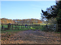
Farm track, Lower Layham
Opposite Overbury Hall.
Image: © Robin Webster
Taken: 19 Nov 2017
0.19 miles
2
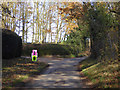
Lane by Overbury Hall
The arrows were for 5 (pink) and 10 mile runs which were shortly due to start from Hadleigh.
Image: © Robin Webster
Taken: 19 Nov 2017
0.21 miles
3
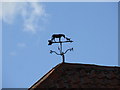
Horse and dog weather vane
Horse and dog weather vane on a building at Shepherd's farm near to Lower Layham Suffolk.
Image: © Keith Evans
Taken: 17 Oct 2007
0.22 miles
4
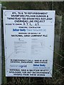
Overhead line project notice
Notice to carry out work on overhead power lines near to Hadleigh Suffolk. For view power lines see http://www.geograph.org.uk/photo/588358
Image: © Keith Evans
Taken: 17 Oct 2007
0.24 miles