IMAGES TAKEN NEAR TO
Shelley, IPSWICH, IP7 5RF
Introduction
This page details the photographs taken nearby to IP7 5RF by members of the Geograph project.
The Geograph project started in 2005 with the aim of publishing, organising and preserving representative images for every square kilometre of Great Britain, Ireland and the Isle of Man.

There are currently over 7.5m images from over14,400 individuals and you can help contribute to the project by visiting https://www.geograph.org.uk
Image Map
Images are licensed for reuse under creativecommons.org/licenses/by-sa/2.0
Notes
- Clicking on the map will re-center to the selected point.
- The higher the marker number, the further away the image location is from the centre of the postcode.
Image Listing (5 Images Found)
Images are licensed for reuse under creativecommons.org/licenses/by-sa/2.0
Image
Details
Distance
1
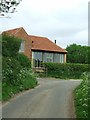
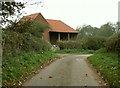
Newlands Barn
This is a very recently converted barn in Becketts Lane near to Withermarsh Green, Suffolk. See http://www.geograph.org.uk/photo/275418 for photo taken 18 months earlier.
Image: © Keith Evans
Taken: 15 May 2008
0.00 miles
3
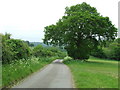
Becketts Lane
Looking south from the north end of Becketts Lane near to Withermarsh Green Suffolk.
Image: © Keith Evans
Taken: 15 May 2008
0.17 miles
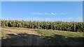
5
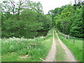
Snakes Wood
Looking north towards Snakes Wood near to Withermarsh Green, Suffolk.
Image: © Keith Evans
Taken: 15 May 2008
0.20 miles