IMAGES TAKEN NEAR TO
Lower Raydon, IPSWICH, IP7 5QL
Introduction
This page details the photographs taken nearby to IP7 5QL by members of the Geograph project.
The Geograph project started in 2005 with the aim of publishing, organising and preserving representative images for every square kilometre of Great Britain, Ireland and the Isle of Man.

There are currently over 7.5m images from over14,400 individuals and you can help contribute to the project by visiting https://www.geograph.org.uk
Image Map
Images are licensed for reuse under creativecommons.org/licenses/by-sa/2.0
Notes
- Clicking on the map will re-center to the selected point.
- The higher the marker number, the further away the image location is from the centre of the postcode.
Image Listing (8 Images Found)
Images are licensed for reuse under creativecommons.org/licenses/by-sa/2.0
Image
Details
Distance
1
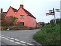
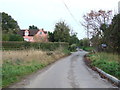
Fox Farm
Road junction and Fox Farm house near to Shelley, Suffolk
Image: © Keith Evans
Taken: 7 Nov 2013
0.10 miles
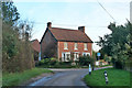
3
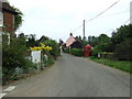
Thatched Cottage
Thatched cottage at the bottom of Higham Hill near to Shelley, Suffolk.
Image: © Keith Evans
Taken: 7 Nov 2013
0.18 miles
4
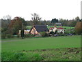
Shelley
The main street through Shelley Suffolk.
Image: © Keith Evans
Taken: 15 May 2008
0.19 miles
5
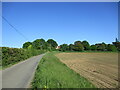
Country Road
Country road near to Shelley, Suffolk.
Image: © Keith Evans
Taken: 7 Nov 2013
0.20 miles
6
House at Priory Farm
It has been sold, according to the sign.
Image: © Robin Webster
Taken: 13 Jan 2016
0.24 miles
7
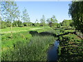
The River Brett at Shelley Bridge
Looking downstream.
Image: © Jonathan Thacker
Taken: 14 May 2022
0.24 miles
8
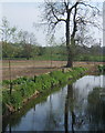
River Brett at Shelley
Looking south from the bridge carrying the lane to Lower Raydon.
Image: © Andrew Hill
Taken: 21 Apr 2009
0.24 miles