IMAGES TAKEN NEAR TO
Pond Hall Road, IPSWICH, IP7 5PJ
Introduction
This page details the photographs taken nearby to Pond Hall Road, IP7 5PJ by members of the Geograph project.
The Geograph project started in 2005 with the aim of publishing, organising and preserving representative images for every square kilometre of Great Britain, Ireland and the Isle of Man.

There are currently over 7.5m images from over14,400 individuals and you can help contribute to the project by visiting https://www.geograph.org.uk
Image Map
Images are licensed for reuse under creativecommons.org/licenses/by-sa/2.0
Notes
- Clicking on the map will re-center to the selected point.
- The higher the marker number, the further away the image location is from the centre of the postcode.
Image Listing (5 Images Found)
Images are licensed for reuse under creativecommons.org/licenses/by-sa/2.0
Image
Details
Distance
1
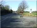
Country Road And Bridleway
Country and bridleway leading to the A1071 near Wolves Wood near to Upper Layham, Suffolk.
Image: © Keith Evans
Taken: 2 Feb 2012
0.05 miles
2
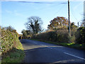
Pond Hall Road
From Hadleigh towards Ipswich.
Image: © Robin Webster
Taken: 19 Nov 2017
0.10 miles
3
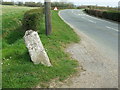
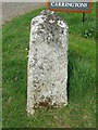
Old Milepost
Old milepost near to Upper Layham, Suffolk. For close up view see http://www.geograph.org.uk/photo/1238779 and for more info on the post see http://milestones.megalithia.com/sites/tm042420.htm do have a look at their home page.
Image: © Keith Evans
Taken: 6 Apr 2009
0.19 miles
4
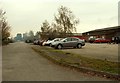
Business Units, just off Pond Hall Road
Image: © Robert Edwards
Taken: 10 Nov 2006
0.20 miles
5
To Hadleigh 1
Old milepost near to Upper Layham, Suffolk. For overall view see http://www.geograph.org.uk/photo/1238771 and for more info on the post see http://milestones.megalithia.com/sites/tm042420.htm do have a look at their home page.
Image: © Keith Evans
Taken: 6 Apr 2009
0.21 miles