IMAGES TAKEN NEAR TO
Layham Road, IPSWICH, IP7 5NB
Introduction
This page details the photographs taken nearby to Layham Road, IP7 5NB by members of the Geograph project.
The Geograph project started in 2005 with the aim of publishing, organising and preserving representative images for every square kilometre of Great Britain, Ireland and the Isle of Man.

There are currently over 7.5m images from over14,400 individuals and you can help contribute to the project by visiting https://www.geograph.org.uk
Image Map
Images are licensed for reuse under creativecommons.org/licenses/by-sa/2.0
Notes
- Clicking on the map will re-center to the selected point.
- The higher the marker number, the further away the image location is from the centre of the postcode.
Image Listing (7 Images Found)
Images are licensed for reuse under creativecommons.org/licenses/by-sa/2.0
Image
Details
Distance
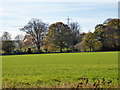
1
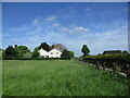
Grass field and house near Lower Layham
Image: © Jonathan Thacker
Taken: 14 May 2022
0.01 miles
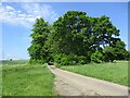
4
The road to Lower Layham
There aren't many nice straight roads in this neck of the woods.
Image: © Adrian S Pye
Taken: 19 Aug 2015
0.17 miles
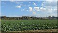
6
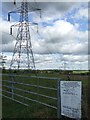
Power lines and notice to carry out work
Power lines and notice to carry out work near to Hadleigh Suffolk. For close up of notice see http://www.geograph.org.uk/photo/588361
Image: © Keith Evans
Taken: 17 Oct 2007
0.24 miles
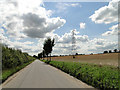
7
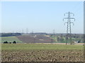
Distant View
Distant view of the power lines near to Upper layham, Suffolk
Image: © Keith Evans
Taken: 17 Feb 2013
0.25 miles